place

Athol Junction

Boston and Albany RailroadEconomy of Springfield, MassachusettsRail junctions in the United States

Athol Junction is a place in Springfield, Massachusetts, named after the rail line that split off to Athol, Massachusetts, before The Quabbin Reservoir was flooded. It is located next to I-291 and the tracks now are used for the industrial park and extend to Indian Orchard before stopping. When the line was active the tracks extended over the Chicopee River, into Ludlow, Massachusetts, and on to Athol. The Athol and Enfield Railroad and the Springfield and North-Eastern Railroad were chartered in 1869, and succeeded by the Springfield, Athol and Northeastern Railroad in 1872, opening in 1873 as a branch from Athol Junction in Springfield to the Vermont and Massachusetts Railroad in Athol. The B&A bought the line in 1880. The majority of the line was closed in the 1930s due to the formation of the Quabbin Reservoir.

Excerpt from the Wikipedia article Athol Junction (License: CC BY-SA 3.0, Authors).

Athol Junction
Springfield Expressway, Springfield

Geographical coordinates (GPS) Address Nearby Places
placeShow on map

Wikipedia: Athol JunctionContinue reading on Wikipedia

Geographical coordinates (GPS)

Latitude Longitude
N 42.131566666667 ° E -72.558675 °
placeShow on map

Address

Springfield Expressway

Springfield Expressway
01104 Springfield
Massachusetts, United States
mapOpen on Google Maps

Share experience

Nearby Places

New Bay Diner Restaurant

The New Bay Diner Restaurant is a historic diner in Springfield, Massachusetts. It was manufactured by the Mountain View Diners Company in Signac, New Jersey (as #532) in 1957; it is believed to be the second-to-last diner the company built before it shut down later that year. The diner is attached to a concrete block structure which houses the kitchen and restrooms, and appears to also date to 1957. At the time of its listing on the National Register of Historic Places in 2003, it was one of six surviving Mountain View diners in Massachusetts, and the only diner remaining in Springfield.When the diner was listed in Springfield's 1964 business directory, it was called the New Bay Diner Restaurant, and its owner was listed as Anthony Viamare of Granby, Massachusetts. Viamare owned it until 1988, when it was acquired by Donald Roy. He changed its name to the "Route 66 Diner", which is its present name. The diner is of steel frame construction, seven window bays wide, with rounded corners. It is mounted on a concrete and brick foundation, has red horizontal banding, and a rounded rubber membrane roof. The doors are steel and glass, although elements of the vestibule do not appear to be original. Its windows are plate glass, separated by steel pilasters. There are signs on the roof, facing east and west, with the diner's name, "Route 66 Diner"; the "Diner" is highlighted in neon. Inside, the diner has a full length counter, with staff access points at the center and the left side. Access to the kitchen is by a door in the center. The diner has seventeen stools and six booths. Its interior decoration is largely original; the countertop has been replaced.

New England Westinghouse Company

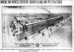
The New England Westinghouse Company is a former division of Westinghouse Electric. It was founded in 1915 in East Springfield, Massachusetts. Its primary purpose was to fulfill a contract to produce 1.8 million Mosin–Nagant rifles for Czar Nicholas II of Russia during World War I. In order to produce the rifles, they purchased the J Stevens Arms & Tool Company in Chicopee Falls, Massachusetts on 1 July 1916 and acquired all its holdings which included firearms and tool manufacturing facilities, and the Stevens-Duryea automobile factory. They sold the tool manufacturing portion of Stevens and shut down production of Stevens-Duryea automobiles and civilian firearms. The remaining Stevens firearms facility was renamed the J Stevens Arms Company and its machinery was retooled to meet the Mosin–Nagant contract. After some 770,000 rifles had been produced, the Czar was deposed in March 1917. Nonetheless, the Russian Embassy in Washington, D.C. still under the direction of Provisional Government Ambassador Boris Bakhmeteff, made financial arrangements with the U.S. State Department and the U.S. Treasury Department on 20 December 1917 for National City Bank to make payments of $325,000 to the Remington Company for rifles and $2,075,000 to J.P. Morgan in connection with a Westinghouse arms contract.The company entered hard times and started producing M1918 Browning Automatic Rifles at the former Stevens-Duryea factory that was originally constructed for car manufacturing in 1912. In 1920 they sold the J Stevens Arms Company to Savage Arms but kept the automobile factory for use producing commercial products for Westinghouse Electric. In 1921, the Stevens-Duryea factory was the location of the first broadcasts of WBZ (AM), the first commercial radio station in the United States.New England Westinghouse was dissolved on 8 October 1926 by the Supreme Judicial Court of Suffolk County, Massachusetts. Westinghouse continued to operate the facility until its closure, with a foundry and knitting company operating at the factory location. The buildings were demolished (with the exception of the Westinghouse office building along Page Blvd.) and the land cleared in 2010, with the eventual goal of placing a mixed development on the site.In 2009–2011, Ameristar Casinos (now under Pinnacle Entertainment) acquired use of this property for a $910 million resort casino, paying $16 million for the property. However, the proposal was eventually dropped in the face of competition from MGM and Penn National Gaming, who also wanted to build casinos in Springfield. MGM would eventually win the rights to build in Springfield.

Winchester Square Historic District

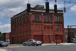
Winchester Square Historic District is a historic district encompassing a cluster of brick buildings at and near the intersection of State Street and Wilbraham Road on the east side of Springfield, Massachusetts. The buildings, most of which were built for industrial purposes, are clustered on five parcels, and were built between 1875 and 1913. It includes the Armory railroad station (1875), the Winchester Square fire station (1886, remodeled 1915), the Knox Automobile Company buildings (1891-1910), and the Indian Motorcycle Company plant, part of which later became the Springfield Industrial Institute complex. The district was listed on the National Register of Historic Places in 1979.The district became a target for industrial development after the construction of the Springfield and New London Railroad in 1870, which included a stop nearby. The oldest building in the district is that of the Bullard Repeating Arms Company, built in 1883 for a company that manufactured rifles. Its founder Jean Bullard, a prolific inventor, also built an early steam-powered automobile in 1887. One building was eventually taken over in 1895 by the Springfield Industrial Institute, which trained generations of workmen for Springfield's industries. The fire station was built to meet the demand for improved fire department response time in the developing area. The Hendee Manufacturing Company, later Indian, began operations in this district upon its organization in 1901; in 1914 it was the world's largest maker of motorcycles. It operated here until 1948, and closed its last plant in 1953.

McKnight District
McKnight District

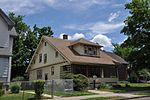
The McKnight District is a predominantly residential neighborhood northeast of downtown Springfield, Massachusetts. The area represents a planned residential development covering several hundred acres, which was built in the mid to late 19th century. The architects of the development were John and William McKnight, who, in addition to developing and enforcing construction guidelines in the area, built and landscaped many of the properties. The area was largely built by 1910, and there has been little new construction in the area since. Most of the houses built in the area were constructed in most of the architectural styles that were popular between 1880 and 1990, although there is a predominance of the Queen Anne style. The McKnights began to develop the area, which had previously been mainly farmland, in 1870 with the purchase of a 22 acres (8.9 ha) parcel on which they and a partner built their own homes. They proceeded over the following years to acquire additional parcels of land in the area, plat out roads, and either build houses themselves, or sell plots to other builders. They enforced some uniformity in the area through the use of deed restrictions, which required uniform setback requirements, banned fencing, and required a minimum cost of construction (the latter to prevent the building of inexpensive tenement-style housing).The neighborhood is roughly defined by the railroad tracks on the north and the Bay Street to the south. On the west it is roughly bounded by Armory and Magazine Streets, and on the east by Monmouth, Clifford, Bay, and Marion Streets. A portion of the neighborhood, encompassing some 130 acres (53 ha) and 350 homes, was designated a historic district and listed on the National Register of Historic Places in 1976. This was expanded in 1986 to 250 acres (100 ha) and 884 properties, encompassing virtually the entirety of the McKnight's development.