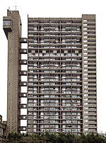
Kensal Town
Areas of LondonDistricts of the City of WestminsterDistricts of the Royal Borough of Kensington and ChelseaLondon geography stubsUse British English from September 2015

Kensal Town is a district located partly in the Royal Borough of Kensington and Chelsea, and partly in the City of Westminster. The area lies four miles north-west of Charing Cross and is part of the W postcode area. Kensal Town was an exclave of Chelsea from the middle ages, through to 1900.
Excerpt from the Wikipedia article Kensal Town (License: CC BY-SA 3.0, Authors, Images).Kensal Town
Appleford Road, London North Kensington (Royal Borough of Kensington and Chelsea)
Geographical coordinates (GPS) Address Phone number Website Nearby Places Show on map
Geographical coordinates (GPS)
| Latitude | Longitude |
|---|---|
| N 51.524 ° | E -0.21 ° |
Address
St Thomas' CofE Primary School
Appleford Road
W10 5EF London, North Kensington (Royal Borough of Kensington and Chelsea, Kensal New Town Estate)
England, United Kingdom
Open on Google Maps


