Wollaston, Northamptonshire
Civil parishes in NorthamptonshireNorth NorthamptonshireUse British English from March 2014Villages in Northamptonshire

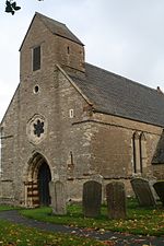
Wollaston is a village and civil parish in North Northamptonshire, England, about 3 miles (5 km) south of the market town of Wellingborough. The 2011 census recorded the population of the parish, including Strixton, as 3,491.[1]Wollaston is from 160 to 260 feet (50 to 80 m) above sea level on hills east of the Nene valley. The soil is clay over subsoil and is on the old Wellingborough to London road. Summer Leys Local Nature reserve is nearby. The Domesday Book of 1086 records the toponym as Wilavestone. In a document written in 1190 it is spelt Wullaueston. The name comes from Old English and is believed to mean the farmstead or village of a man named Wulfaf.[2]
Excerpt from the Wikipedia article Wollaston, Northamptonshire (License: CC BY-SA 3.0, Authors, Images).Wollaston, Northamptonshire
Eastfield Road,
Geographical coordinates (GPS) Address Nearby Places Show on map
Geographical coordinates (GPS)
| Latitude | Longitude |
|---|---|
| N 52.256388888889 ° | E -0.66944444444444 ° |
Address
Eastfield Road 12
NN29 7RU
England, United Kingdom
Open on Google Maps


