Froxfield

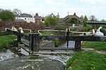
Froxfield is a village and civil parish in the English county of Wiltshire. The parish is on the Wiltshire-West Berkshire border, and the village lies on the A4 national route about 2.5 miles (4 km) west of Hungerford and 7 miles (11 km) east of Marlborough. Froxfield village is on a stream that is a tributary of the River Dun. The road between London and Bristol follows the valley of the stream and passes through the village, having followed this course since at least the 13th century. The Kennet and Avon Canal follows the Dun valley through Froxfield parish, passing within 550 yards (500 m) of the village. The canal has a series of locks in the parish, from Oakhill Down Lock to Froxfield Bottom Lock. The Reading to Taunton railway line also follows the river through the parish below the village.
Excerpt from the Wikipedia article Froxfield (License: CC BY-SA 3.0, Authors, Images).Froxfield
Bath Road,
Geographical coordinates (GPS) Address Nearby Places Show on map
Geographical coordinates (GPS)
| Latitude | Longitude |
|---|---|
| N 51.41 ° | E -1.574 ° |
Address
Bath Road
Bath Road
SN8 3JY , Froxfield
England, United Kingdom
Open on Google Maps


