Southbourne, West Sussex
Chichester DistrictCivil parishes in West SussexSouthbourne, West SussexVillages in West Sussex

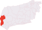
Southbourne is a village and civil parish in the Chichester district of West Sussex, England. It lies to the east of the Hampshire County Border at Emsworth, the west of Chidham (recently the boundary has been changed) and south-east of Westbourne. Southbourne parish comprises Lumley, Hermitage, Thornham, Prinsted and part of Nutbourne.
Excerpt from the Wikipedia article Southbourne, West Sussex (License: CC BY-SA 3.0, Authors, Images).Southbourne, West Sussex
Main Road, Chichester Southbourne
Geographical coordinates (GPS) Address Website Nearby Places Show on map
Geographical coordinates (GPS)
| Latitude | Longitude |
|---|---|
| N 50.84503 ° | E -0.90811 ° |
Address
Pets Corner
Main Road 306
PO10 8JN Chichester, Southbourne
England, United Kingdom
Open on Google Maps

