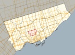
Toronto—St. Paul's

Toronto—St. Paul's is a federal electoral district in Toronto, Ontario, Canada, that has been represented in the House of Commons of Canada since 1935. Its current MP is Carolyn Bennett. Prior to the 2015 election, the riding was known as St. Paul's.The small but densely populated riding covers the area to the north and northeast of Downtown Toronto (often called "Midtown" Toronto). In the past, it had been considered a bellwether riding, having been represented by only three opposition MPs. However, like most Toronto-based ridings, the Liberals have dominated recent elections. Since the Liberals won all but one seat in Ontario in their 1993 landslide, they have won all but one election in St. Paul's by 10,000 votes or more. As of 2015, it includes the southern two-thirds of the wealthy Toronto neighbourhood of Forest Hill, plus the neighbourhoods of Deer Park, Davisville Village, Chaplin Estates, South Hill, Humewood-Cedarvale, the southern two-thirds of Fairbank, and the northern half of Summerhill.
Excerpt from the Wikipedia article Toronto—St. Paul's (License: CC BY-SA 3.0, Authors, Images).Toronto—St. Paul's
Forest Hill Road, Old Toronto
Geographical coordinates (GPS) Address Nearby Places Show on map
Geographical coordinates (GPS)
| Latitude | Longitude |
|---|---|
| N 43.696 ° | E -79.4076 ° |
Address
Forest Hill Road 164
M5P 2K3 Old Toronto
Ontario, Canada
Open on Google Maps


