place

Southoe

EngvarB from July 2016Former civil parishes in CambridgeshireHuntingdonshireVillages in Cambridgeshire
St Leonard's church, Southoe geograph.org.uk 1260989

Southoe is a small village and former civil parish, now in the parish of Southoe and Midloe, in Cambridgeshire, England. Southoe lies approximately 6 miles (10 km) south-west of Huntingdon on the A1. Southoe is situated within Huntingdonshire which is a non-metropolitan district of Cambridgeshire as well as being a historic county of England. In 1931 the parish had a population of 211.The church is central in the village and the south doorway contains parts that are of Norman origin.

Excerpt from the Wikipedia article Southoe (License: CC BY-SA 3.0, Authors, Images).

Southoe
High Street, Huntingdonshire Little Paxton

Geographical coordinates (GPS) Address Nearby Places
placeShow on map

Wikipedia: SouthoeContinue reading on Wikipedia

Geographical coordinates (GPS)

Latitude Longitude
N 52.25 ° E -0.25 °
placeShow on map

Address

Paxton Pits

High Street
PE19 6HA Huntingdonshire, Little Paxton
England, United Kingdom
mapOpen on Google Maps

St Leonard's church, Southoe geograph.org.uk 1260989
Share experience

Nearby Places

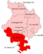
St Neots Rural District

St Neots was a rural district in Huntingdonshire, England from 1894 to 1974, around the northern and eastern sides of the urban area of St Neots. The district had its origins in the St Neots Rural Sanitary District. This had been created under the Public Health Acts of 1872 and 1875, giving public health and local government responsibilities for rural areas to the existing Boards of Guardians of Poor Law Unions.Under the Local Government Act 1894, Rural Sanitary Districts became Rural Districts from 28 December 1894, and rural sanitary districts which straddled county boundaries were to be split so that separate rural districts were created for the parts in each county. Generally, the Huntingdonshire part of the St Neots Rural Sanitary District became the St Neots Rural District, whilst the Bedfordshire part became the Eaton Socon Rural District. As an exception to this rule, the Bedfordshire and Huntingdonshire County Councils agreed that the parish of Swineshead, despite being in Huntingdonshire, would be included in the Eaton Socon Rural District as it was surrounded by Bedfordshire parishes. Similarly, the parish of Tilbrook in Bedfordshire was included in the St Neots Rural District as it formed a long salient sticking out from Bedfordshire into territory almost surrounded by Huntingdonshire. The county boundary was changed two years later to match the boundary which had been agreed for the Rural Districts, with Swineshead becoming part of Bedfordshire and Tilbrook part of Huntingdonshire on 30 September 1896.St Neots Rural District was expanded in 1935 by taking in Covington parish from the disbanded Thrapston Rural District. In 1965 Huntingdonshire and the Soke of Peterborough merged to form Huntingdon and Peterborough. In 1974 the district was abolished under the Local Government Act 1972 and became part of the non-metropolitan district of Huntingdon, subsequently renamed Huntingdonshire. A small area was transferred to Bedfordshire.