place

Paxton Pits Nature Reserve

Cambridgeshire geography stubsNature reserves in Cambridgeshire
Paxton Pits
Paxton Pits

Paxton Pits is an area of active and disused gravel pits at Little Paxton near St Neots in Cambridgeshire, England. The disused pits have been turned into a nature reserve with 77 hectares of lakes, meadow, grassland, scrub and woodland. The reserve is famous for its nightingales and cormorants and is home to a wide variety of other birds, insects, mammals and flora. There are two marked self guided walking routes around the reserve, together with the Rivet Trail that follows the route of the Ouse Valley Way. The circular 2 mile Heron Trail (the first mile of which is a hard surfaced track suitable for wheelchairs, pushchairs and all season walking) goes past lakes, through woodland and along the river bank, and which has three bird hides to view the water birds. The circular 1.5 mile Meadow Trail goes through meadows and around lakes and is especially good for wildflowers in spring and summer and dragonflies on sunny days, although some of the paths become quite muddy in winter and during wet weather. The reserve has free parking at the visitor and education centre, with a cafe and toilets.

Excerpt from the Wikipedia article Paxton Pits Nature Reserve (License: CC BY-SA 3.0, Authors, Images).

Paxton Pits Nature Reserve
High Street, Huntingdonshire Little Paxton

Geographical coordinates (GPS) Address External links Nearby Places
placeShow on map

Wikipedia: Paxton Pits Nature ReserveContinue reading on Wikipedia

Geographical coordinates (GPS)

Latitude Longitude
N 52.2542 ° E -0.2483 °
placeShow on map

Address

Paxton Pits

High Street
PE19 6HA Huntingdonshire, Little Paxton
England, United Kingdom
mapOpen on Google Maps

linkWikiData (Q7156531)
linkOpenStreetMap (40243465)

Paxton Pits
Paxton Pits
Share experience

Nearby Places

St Neots Rural District

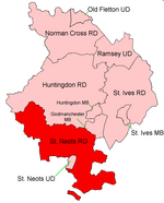
St Neots was a rural district in Huntingdonshire, England from 1894 to 1974, around the northern and eastern sides of the urban area of St Neots. The district had its origins in the St Neots Rural Sanitary District. This had been created under the Public Health Acts of 1872 and 1875, giving public health and local government responsibilities for rural areas to the existing Boards of Guardians of Poor Law Unions.Under the Local Government Act 1894, Rural Sanitary Districts became Rural Districts from 28 December 1894, and rural sanitary districts which straddled county boundaries were to be split so that separate rural districts were created for the parts in each county. Generally, the Huntingdonshire part of the St Neots Rural Sanitary District became the St Neots Rural District, whilst the Bedfordshire part became the Eaton Socon Rural District. As an exception to this rule, the Bedfordshire and Huntingdonshire County Councils agreed that the parish of Swineshead, despite being in Huntingdonshire, would be included in the Eaton Socon Rural District as it was surrounded by Bedfordshire parishes. Similarly, the parish of Tilbrook in Bedfordshire was included in the St Neots Rural District as it formed a long salient sticking out from Bedfordshire into territory almost surrounded by Huntingdonshire. The county boundary was changed two years later to match the boundary which had been agreed for the Rural Districts, with Swineshead becoming part of Bedfordshire and Tilbrook part of Huntingdonshire on 30 September 1896.St Neots Rural District was expanded in 1935 by taking in Covington parish from the disbanded Thrapston Rural District. In 1965 Huntingdonshire and the Soke of Peterborough merged to form Huntingdon and Peterborough. In 1974 the district was abolished under the Local Government Act 1972 and became part of the non-metropolitan district of Huntingdon, subsequently renamed Huntingdonshire. A small area was transferred to Bedfordshire.