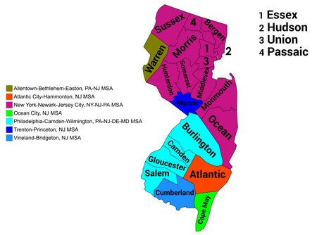
New Jersey statistical areas
New Jersey geography-related listsUnited States statistical areas

The U.S. State of New Jersey currently has nine statistical areas that have been delineated by the Office of Management and Budget (OMB). On March 6, 2020, the OMB delineated two combined statistical areas and seven metropolitan statistical areas in New Jersey. New Jersey is the most urban of the 50 U.S. states with the highest population density of any state. Each of the 21 counties of New Jersey is located in one of the seven metropolitan statistical areas.
Excerpt from the Wikipedia article New Jersey statistical areas (License: CC BY-SA 3.0, Authors, Images).New Jersey statistical areas
Apollo Drive,
Geographical coordinates (GPS) Address Nearby Places Show on map
Geographical coordinates (GPS)
| Latitude | Longitude |
|---|---|
| N 40.1907 ° | E -74.6728 ° |
Address
Sunnybrae Elementary School
Apollo Drive
08620
New Jersey, United States
Open on Google Maps


