place

Chesapeake Bay Bridge
1952 establishments in MarylandBridges completed in 1952Bridges completed in 1973Bridges in Anne Arundel County, MarylandBridges in Queen Anne's County, Maryland
Bridges of the United States Numbered Highway SystemCantilever bridges in the United StatesChesapeake BayConcrete bridges in the United StatesGirder bridges in the United StatesIntracoastal WaterwayRoad bridges in MarylandRoads with a reversible laneSteel bridges in the United StatesSuspension bridges in MarylandThrough arch bridges in the United StatesToll bridges in MarylandTowers in MarylandU.S. Route 301U.S. Route 50Use mdy dates from October 2020
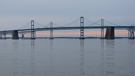
Chesapeake Bay Bridge viewed from Sandy Point State Park

The Chesapeake Bay Bridge (also known locally as the Bay Bridge) is a major dual-span bridge in the U.S. state of Maryland. Spanning the Chesapeake Bay, it connects the state's rural Eastern Shore region with the urban Western Shore, between Stevensville and the capital city of Annapolis. The original span, opened in 1952 and with a length of 4.3 miles (6.9 km), was the world's longest continuous over-water steel structure. The parallel span was added in 1973. The bridge is officially named the Gov. William Preston Lane Jr. Memorial Bridge after William Preston Lane Jr. who, as the 52nd Governor of Maryland, initiated its construction in the late 1940s finally after decades of political indecision and public controversy. The bridge is part of U.S. Route 50 (US 50) and US 301, and serves as a vital link in both routes. As part of cross-country US 50, it connects the Baltimore–Washington Metropolitan Area with Ocean City, Maryland, Rehoboth Beach, Delaware, and other coastal tourist resort destinations. As part of US 301, it serves as part of an alternative route for Interstate 95 travelers, between northern Delaware and the Washington, D.C., area. Because of this linkage, the bridge is busy and has become known as a point of traffic congestion, particularly during peak hours and summer months. The bridge's role in transportation was filled by ferries prior to the first span's construction. An annual 10K run across the bridge has been organized on-and-off since 1975. The bridge's economic impact on the areas it connects has been significant, with both Queen Anne's County and Ocean City expanding significantly since the bridge's construction. Future expansion of the bridge has been discussed since 2004, with a task force being formed to investigate the possibility of building a third span. Because of similar names, it is often confused with the Chesapeake Bay Bridge–Tunnel, a bridge–tunnel linking the Eastern Shore of Virginia with the Hampton Roads region and the rest of Virginia.

Excerpt from the Wikipedia article Chesapeake Bay Bridge (License: CC BY-SA 3.0, Authors, Images).

Chesapeake Bay Bridge
Chesapeake Bay Bridge,

Geographical coordinates (GPS) Address External links Nearby Places
placeShow on map

Wikipedia: Chesapeake Bay BridgeContinue reading on Wikipedia

Geographical coordinates (GPS)

Latitude Longitude
N 38.991666666667 ° E -76.372222222222 °
placeShow on map

Address

Chesapeake Bay Bridge (William Preston Lane, Jr. Memorial Bridge)

Chesapeake Bay Bridge
21666
Maryland, United States
mapOpen on Google Maps

linkWikiData (Q1319988)
linkOpenStreetMap (27164664)

Chesapeake Bay Bridge viewed from Sandy Point State Park
Share experience

Nearby Places

Sandy Point Shoal Light

Sandy Point Shoal Light is a brick three story lighthouse on a caisson foundation that was erected in 1883. It lies about 0.6 mi (0.97 km) off Sandy Point, north of the Chesapeake Bay Bridge, from whose westbound span it is readily visible.The current light replaced a brick tower on the point itself, integral to the keeper's house, which was erected in 1857. By 1874 the Lighthouse Board complained that the extent of the shoal and the poor equipment of the lighthouse made a new light necessary; appropriations were not forthcoming, however, until 1882. The whole gamut of light sources has been run, from oil wicks to incandescent oil vapor (1913) to electricity (1929). The characteristic changed from flashing to fixed and back to flashing along with the change in light source. The present light is powered by a pair of solar panels attached to the roof on the south side.After automation in 1963, the light became subject to vandalism due to its visibility and its accessibility. The original lens was destroyed in 1979, apparently smashed with a baseball bat. Though the Coast Guard made efforts at maintaining and restoring the structure from 1988 to 1990, it continued to deteriorate. In 2006 it was sold at auction to a private bidder, after an unsuccessful attempt to find a non-profit group to take responsibility for the light. The Coast Guard continued to maintain the navigation aids until June 2019, when the light was discontinued due to deterioration of the privately owned supporting structure. The structure was added to the National Register of Historic Places as Sandy Point Shoal Light Station on December 2, 2002.