Northfield Mountain

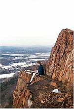
Northfield Mountain, 1,206 feet (368 m), is a mountain ridge located in Erving and Northfield, Massachusetts. 2.5 miles (4.0 km) long by 1.8 miles (2.9 km) long, the mountain is composed of several distinct peaks and ledges, most notably Rattlesnake Mountain (also known as Farley Ledge) 1,067 feet (325 m), Rose Ledges 1,080 feet (330 m), and Hermit Mountain (the high point). A pumped-storage hydroelectric plant and reservoir occupies the top of the mountain west of the summit. The 114-mile (183 km) Metacomet-Monadnock Trail crosses the summit ridge of Northfield Mountain; a series of shorter hiking trails, cross country ski trails, a cross-country running course, and rock climbing routes are also located on the mountain and its ledges. Northfield Mountain is located at the confluence of the Connecticut River and Millers River. A waterfall, Briggs Brook Falls, plunges from its southeast side.
Excerpt from the Wikipedia article Northfield Mountain (License: CC BY-SA 3.0, Authors, Images).Northfield Mountain
NET/M&M Trail,
Geographical coordinates (GPS) Address Website Nearby Places Show on map
Geographical coordinates (GPS)
| Latitude | Longitude |
|---|---|
| N 42.615277777778 ° | E -72.424166666667 ° |
Address
NET/M&M Trail (New England Trail NET)
NET/M&M Trail
Massachusetts, United States
Open on Google Maps


