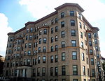
Columbia Heights (Washington, D.C.)

Columbia Heights is a neighborhood in Northwest Washington, D.C., United States. It has diverse demographics, the DC USA shopping mall and many restaurants, BloomBars, Meridian Hill/Malcolm X Park, Howard University, Banneker Recreation Center, and All Souls Church.Developed as a Washington suburb after the American Civil War, growth accelerated in the early 1900s. The extension of the DC streetcar system in 1914 made the neighborhood a popular place to live among federal workers. In the 1940s, the designation of Cardozo High School as a "colored" school resulted in a demographic shift and the neighborhood became predominantly African-American. The 1968 Washington, D.C., riots devastated the area and turmoil in the 1970s and 1980s followed. Beginning in the late 1990s, the addition of a Washington Metro station and other initiatives led to the redevelopment of the neighborhood. Columbia Heights has been listed as one of D.C.'s neighborhoods where home sellers get more than asking price. Unlike some gentrified neighborhoods in the city, Columbia Heights has not become homogeneous: "white, Asian, black and Latino residents each make up at least 10% of the population—and no group constitutes a majority." It has been described as "a perfect little microcosm of D.C." Housing includes high-priced condominiums and townhouses, as well as public and middle-income housing, and million-dollar homes.
Excerpt from the Wikipedia article Columbia Heights (Washington, D.C.) (License: CC BY-SA 3.0, Authors, Images).Columbia Heights (Washington, D.C.)
Fairmont Street Northwest, Washington Columbia Heights
Geographical coordinates (GPS) Address Nearby Places Show on map
Geographical coordinates (GPS)
| Latitude | Longitude |
|---|---|
| N 38.925 ° | E -77.03 ° |
Address
Fairmont Street Northwest 1303
20009 Washington, Columbia Heights
District of Columbia, United States
Open on Google Maps


