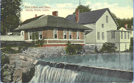
Sandy Hook, Connecticut
1711 establishments in ConnecticutCensus-designated places in ConnecticutCensus-designated places in Fairfield County, ConnecticutNewtown, ConnecticutPopulated places established in 1711 ... and 2 more
Villages in ConnecticutVillages in Fairfield County, Connecticut

Sandy Hook is a village in the town of Newtown, Connecticut. It was founded in 1711. It was listed as a census-designated place prior to the 2020 census.Sandy Hook borders the village of Botsford, the Newtown borough, and the towns of Monroe, Southbury, and Oxford along the Housatonic River. The village of Sandy Hook includes the communities of Berkshire, Riverside, Walnut Tree Hill, and Zoar. It also extends for a short distance into the town of Monroe along Old Zoar Road and Bagburn Hill/Jordan Hill Road.
Excerpt from the Wikipedia article Sandy Hook, Connecticut (License: CC BY-SA 3.0, Authors, Images).Sandy Hook, Connecticut
Washington Avenue,
Geographical coordinates (GPS) Address Nearby Places Show on map
Geographical coordinates (GPS)
| Latitude | Longitude |
|---|---|
| N 41.42 ° | E -73.281944444444 ° |
Address
Washington Avenue 4
06482
Connecticut, United States
Open on Google Maps


