place

Union Street, Aberdeen

Shopping streets in ScotlandStreets in AberdeenUse British English from July 2017
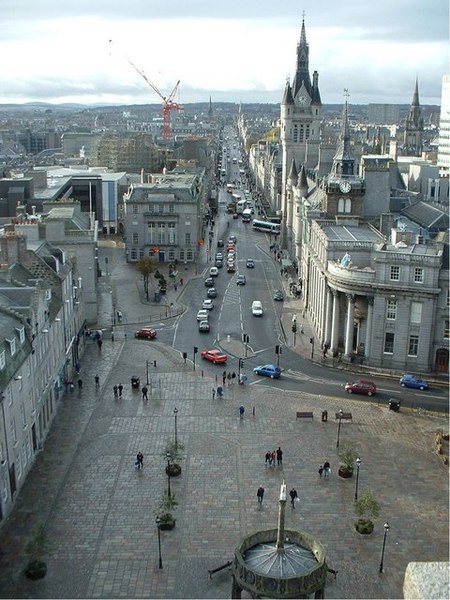
UnionStreet 287149 Lyn Mcleod

Union Street is a major street and shopping thoroughfare in Aberdeen, Scotland. It is named after the Acts of Union 1800 with Ireland. The street is approximately one mile long (0.8 miles) and a feat of engineering skill involving the partial levelling of St. Catherine's Hill and the building of arches to carry the street over Putachieside. The Denburn Valley was crossed by Union Street by Union Bridge (constructed 1801–05). The Union Bridge holds the record of the 'Worlds largest single span granite bridge' at 130 feet (40 m) across.

Excerpt from the Wikipedia article Union Street, Aberdeen (License: CC BY-SA 3.0, Authors, Images).

Union Street, Aberdeen
Union Street, Aberdeen City City Centre

Geographical coordinates (GPS) Address Nearby Places
placeShow on map

Wikipedia: Union Street, AberdeenContinue reading on Wikipedia

Geographical coordinates (GPS)

Latitude Longitude
N 57.1457098 ° E -2.1018608 °
placeShow on map

Address

Union Street 161-165
AB11 6BB Aberdeen City, City Centre
Scotland, United Kingdom
mapOpen on Google Maps

UnionStreet 287149 Lyn Mcleod
Share experience

Nearby Places

Belmont Street, Aberdeen

Belmont Street is a north-south street in the centre of Aberdeen, Scotland that runs perpendicular to Union Street. Belmont Street originated with the late 18th century expansion of the town. It was part of an expansion out of the town into suburbs to the west by the towns richer denizens. For example, Thomas Menzies of Pitfodels, one of Aberdeen's wealthiest merchants of the time, moved from his long-standing town house on Castle Street (which is now the site of the North of Scotland Bank) to a five-bay two-storey house on Belmont Street in 1788. The street overlooked the valley of the River Denburn and was developed on vacant ground there in the 1780s, housing there initially comprising the domiciles of the wealthy, typified by large town houses with gardens running down to the river. A few of the houses from the late 18th century still survive on Belmont Street today, including Menzies'.There were several churches on Belmont Street. The Triple Kirks, a free church established in 1844 at the junction of Belmont Street and Schoolhill, was deliberately sited with the intention of rivalling the established "Auld Kirk" of St Nicholas parish. A building to house the unification of the East, South, and West free churches of the town, it was designed by Archibald Simpson. There is now a pub, the Triple Kirks, on the site. The South Church is also on Belmont Street. In November 1779, the anti-Burgher United Presbyterians of north Aberdeen moved to a purpose-built 800-seat church on Belmont Street. The Relief United Presbyterians established a Belmont Street congregation a little after 1778, when funds began to be raised for a 1000-seat church. In 1828, the Belmont Chapel of Ease, as it had come to be, became a fully fledged parish church, under the ministership of Reverend John Bryce.

Lang Stane, Aberdeen

The Lang Stane in Aberdeen, Scotland is a granite Menhir type standing stone that sits recessed into an alcove at the south east corner of 10 Langstane Place, just off Aberdeen's main thoroughfare Union Street. There is suggestion that the nearby Crabstane and the Lang Stane were both used as boundary stones of Craibstone Croft, site of the Battle of Craibstone in 1571. Whilst close to its location as a boundary marker its current site is unlikely to be the exact location of the Craibstone boundary as it would have been moved during the construction of Union Street and the surrounding infrastructure. Prior to this the stone was probably part of a stone circle, the conclusion taken as the base has been carved into a keel shape- common of recumbent stone circles found in Aberdeenshire, which usually date to approximately 3000BC. The stone has dimensions of 1.8m height, 0.68m breadth and approximately 0.3m thickness.On Paterson's Map of the Burgh of Aberdeen printed in 1746 prior to the construction of Langstane Place, the stone can be seen in approximately its current location, though it does not appear as part of a stone circle. Throughout the city the name reoccurs with the single word differentiation 'Langstane' - indeed the area of the city where the Lang Stane sits is within the aptly named former Langstane political ward. The title occurs often in local business and areas with examples such as the former Langstane Kirk (now Soul), Langstane Press and Langstane Housing Association. Curiously in the immediate area of Aberdeen there are other standing stones with same name, such as the Lang Stane of Hilton area of the city and the Lang Stane of Auquhollie just south Aberdeen.