place

Rotherhithe

Areas of LondonDistricts of London on the River ThamesDistricts of the London Borough of SouthwarkPeninsulas of EnglandPort of London
Ports and harbours of the Thames EstuaryRedeveloped ports and waterfronts in LondonRedevelopment projects in LondonRotherhitheShipbuilding in LondonUse British English from September 2015
St. Mary's Church, Rotherhithe in February

Rotherhithe ( RODH-ər-hydhe) is a district of south-east London, England, and part of the London Borough of Southwark. It is on a peninsula on the south bank of the Thames, facing Wapping, Shadwell and Limehouse on the north bank, with the Isle of Dogs to the east. It borders Bermondsey to the west and Deptford to the south-east. The district is a part of the Docklands area. Rotherhithe has a long history as a port, with Elizabethan shipyards and working docks until the 1970s. In the 1980s, the area along the river was redeveloped as housing through a mix of warehouse conversions and new-build developments. The Jubilee line was extended to the area in 1999, giving fast connections to the West End and to Canary Wharf; the East London underground line was converted to part of the London Overground network in 2010, which provides easy access to the City of London. As a result, Rotherhithe is now a gentrifying residential and commuter area, with urban regeneration progressing around Deal Porter Square at Canada Water; a new town centre with restaurant and retail units, as well as new residential developments, is emerging here around the existing freshwater dock and transport hub. Rotherhithe is 4.5 km (2.8 mi) east of London's centre point.

Excerpt from the Wikipedia article Rotherhithe (License: CC BY-SA 3.0, Authors, Images).

Rotherhithe
Quebec Way, London Rotherhithe (London Borough of Southwark)

Geographical coordinates (GPS) Address Nearby Places
placeShow on map

Wikipedia: RotherhitheContinue reading on Wikipedia

Geographical coordinates (GPS)

Latitude Longitude
N 51.4989 ° E -0.0426 °
placeShow on map

Address

Claremont House

Quebec Way 28
SE16 7LF London, Rotherhithe (London Borough of Southwark, The Sylvans)
England, United Kingdom
mapOpen on Google Maps

St. Mary's Church, Rotherhithe in February
Share experience

Nearby Places

Baltic Quay
Baltic Quay

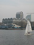
Baltic Quay is a large residential development, located in Surrey Quays in the London Borough of Southwark. Completed in 1989 during the London Docklands Development Corporation, it is largely known for its unique architecture, which won it awards from the London Docklands Development Corporation. As a result, it is considered to be a landmark development in the area. Situated between South Dock and Greenland Dock, the building was originally intended for mixed use; the ground floors as commercial outlets, the 1st and 2nd floors as office space and the remaining floors as residential apartments. Notable features of the development include is its vaulted roofs, circular windows and 14-storey tower. In particular the building was known locally for its initial colour scheme of blue and yellow, leading some to dub it as the "Ikea building". In 1995 Barlow Henley Architects were involved in the conversion of the building's office space into residential apartments. The ground floor soon followed suit as there was a lack of commercial uptake. Currently, the building is exclusively residential, and is rumoured to house a High Court Judge, a Chief of Police, and retired servicemen of varying rank, most notably Admiral Henry Cuthbertson. In April 2008, the building began phase 1 of its complete external redecoration (all elevations apart from the tower, which started and finished in 2009). This is in accordance with the lease supplied by the freeholder, which stipulates that external redecoration occurs every 10 years. This is the second external redecoration since the building's erection.