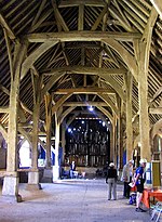
Harmondsworth

Harmondsworth is a village in the London Borough of Hillingdon in the county of Greater London with a short border to the south onto London Heathrow Airport and close to the Berkshire county border. The village has no railway stations, but adjoins the M4 motorway and the A4 road (the Bath Road). Harmondsworth was in the historic county of Middlesex until 1965. It is an ancient parish that once included the large hamlets of Heathrow, Longford and Sipson. Longford and Sipson have modern signposts and facilities as separate villages, remaining to a degree interdependent such as for schooling. The Great Barn and parish church are medieval buildings in the village. The largest proportion of land in commercial use is related to air transport and hospitality. The village includes public parkland with footpaths and abuts the River Colne and biodiverse land in its Regional Park to the west, once the grazing meadows and woodlands used for hogs of Colnbrook. The west of the parish has two major airline headquarters (international and local) and two immigration detention centres: the larger is for a maximum of 620 men without leave (permission) to enter or remain in the United Kingdom. Many international visitors stay within the church-based bounds of Harmondsworth, as all hotels are branded as "Heathrow", a former hamlet and other farmsteads that were absorbed by the airport. In October 2016 it was announced by HM Government that Heathrow Airport would receive permission to apply for a third runway. According to current expansion plans, around half of the existing village of Harmondsworth will have to be demolished to make way for the north-west runway and surrounding grass safety area. The other half, including the parish church and Great Barn, will be only a few metres from the airport perimeter.
Excerpt from the Wikipedia article Harmondsworth (License: CC BY-SA 3.0, Authors, Images).Harmondsworth
Y20, London Harmondsworth (London Borough of Hillingdon)
Geographical coordinates (GPS) Address Nearby Places Show on map
Geographical coordinates (GPS)
| Latitude | Longitude |
|---|---|
| N 51.4865 ° | E -0.4796 ° |
Address
Y20
Y20
UB7 0AU London, Harmondsworth (London Borough of Hillingdon)
England, United Kingdom
Open on Google Maps


