place

The Hills Shire

1906 establishments in AustraliaLocal government areas in SydneyThe Hills ShireUse Australian English from September 2012
Hills Shire Council LGA Sydney 2016

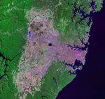
The Hills Shire (from 1906 to 2008 as Baulkham Hills Shire) is a local government area in the Greater Sydney region of Sydney, New South Wales, Australia. The suburb is north-west of the Sydney central business district, and encompasses 401 square kilometres (155 sq mi) stretching from the M2 Hills Motorway in the south to Wiseman's Ferry on the Hawkesbury River in the north. The Hills Shire had a population of 157,243 as at the 2016 census.The current mayor of The Hills Shire is Dr. Peter Gangemi (Liberal), who was elected on 21 December 2021.

Excerpt from the Wikipedia article The Hills Shire (License: CC BY-SA 3.0, Authors, Images).

The Hills Shire
Linton Street, Sydney Baulkham Hills

Geographical coordinates (GPS) Address Nearby Places
placeShow on map

Wikipedia: The Hills ShireContinue reading on Wikipedia

Geographical coordinates (GPS)

Latitude Longitude
N -33.766666666667 ° E 151 °
placeShow on map

Address

Linton Street

Linton Street
2153 Sydney, Baulkham Hills
New South Wales, Australia
mapOpen on Google Maps

Hills Shire Council LGA Sydney 2016
Share experience

Nearby Places

Cumberland Plain
Cumberland Plain

The Cumberland Plain, also known as Cumberland Basin, is a relatively flat region lying to the west of Sydney CBD in New South Wales, Australia. An IBRA biogeographic region, Cumberland Basin is the preferred physiographic and geological term for the low-lying plain of the Permian-Triassic Sydney Basin found between Sydney and the Blue Mountains, and it is a structural sub-basin of the Sydney Basin.The Cumberland Plain has an area of roughly 2,750 square kilometres (1,060 sq mi), which lies on Triassic shales and sandstones. Shaping the geography of Sydney, it extends from 10 kilometres (6.2 mi) north of Windsor in the north, to Picton in the south; and from the Nepean-Hawkesbury River in the west almost to Sydney City, and includes parts of the Inner West and Northern Suburbs in the east. Much of the Sydney metropolitan area is located on the Plain. The Hornsby Plateau is located to the north and is dissected by steep valleys.The plain takes its name from Cumberland County, in which it is situated, one of the cadastral land divisions of New South Wales. The name Cumberland was conferred on the County by Governor Arthur Phillip in honour of Ernest Augustus, Duke of Cumberland. Being the most populous region in Australia, the Cumberland Plain is one of the fastest-growing areas of the country in terms of population and it is home to a variety of Australian animal species, which are observable in the urban environments.

Lake Parramatta
Lake Parramatta

Lake Parramatta is a heritage-listed man-made reservoir and a recreational area located in North Parramatta, City of Parramatta, in the Western Sydney region of New South Wales, Australia. The masonry arch-walled dam across Hunts Creek was completed in 1856 to supply water for domestic purposes; and was operational until 1909. The dam has since been decommissioned and the lake and the surrounding nature reserve are a popular recreational area.The precinct contains a 73-hectare (180-acre) nature reserve, the largest bushland remnant surviving in the Parramatta LGA. The 8-square-kilometre (3.1 sq mi) catchment area for Lake Parramatta is bounded by North Rocks Road, Pennant Hills Road and Hunts Creek. The height of the dam wall is 15 metres (49 ft) and it creates a lake with a maximum storage capacity of 485 megalitres (17.1×10^6 cu ft), with a surface area of approximately 10.5 hectares (26 acres).The dam was the twelfth engineered dam built since Roman times 100BC, the first in Australia, and the second arch built universally that involved calculations for its construction. Water from this dam was not reticulated until 1881 when it was required to augment the then dwindling water supply. The dam wall is listed on the New South Wales State Heritage Register in recognition of its significance relating to dam technology in Australia arch dams worldwide; and has an indicative listing on the Register of the National Estate. It was added to the New South Wales State Heritage Register on 23 March 2012.On 5 December 2012 the Governor proclaimed Lake Parramatta Reserve as a 'Wildlife Refuge’ under Section 68 of the National Parks and Wildlife Act 1974. The proclamation was in recognition of the diversity of wildlife and threatened species which occur in the reserve. Swimming in Lake Parramatta was permitted between 1920 and 1940; and after a prolonged period of closure due to poor water quality, was reopened to the public in 2015. Entry to the reserve is from Lackey Street, North Parramatta.