St. Luzisteig Pass
FläschGraubünden geography stubsLiechtenstein geography stubsMaienfeldMountain passes of Graubünden ... and 2 more
Mountain passes of SwitzerlandMountain passes of the Alps

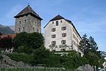
St. Luzisteig Pass (el. 713 m.) is a mountain pass in the Alps between the canton of Graubünden in Switzerland and Liechtenstein. It connects Maienfeld in Graubünden and Balzers in Liechtenstein. Near the pass is a fortification that dates from the 18th century and is still used as a caserne by the Swiss Army. The pass road has a maximum grade of 12 percent.
Excerpt from the Wikipedia article St. Luzisteig Pass (License: CC BY-SA 3.0, Authors, Images).St. Luzisteig Pass
414,
Geographical coordinates (GPS) Address Nearby Places Show on map
Geographical coordinates (GPS)
| Latitude | Longitude |
|---|---|
| N 47.038055555556 ° | E 9.5272222222222 ° |
Address
Schiessplatz Arozenboden
414
7306
Grisons, Switzerland
Open on Google Maps


