Schwägalp Pass
Appenzell Ausserrhoden–St. Gallen borderCanton of St. Gallen geography stubsMountain passes of Appenzell AusserrhodenMountain passes of SwitzerlandMountain passes of the Alps ... and 2 more
Mountain passes of the canton of St. GallenSwitzerland geography stubs

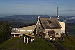
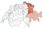
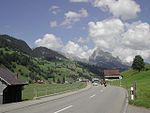
Schwägalp Pass (el. 1,278 m or 4,193 ft) is a high mountain pass in the Alps between the cantons of St. Gallen and Appenzell Ausserrhoden in Switzerland. It connects Nesslau-Neu St. Johann in Toggenburg in St. Gallen and Urnäsch in Appenzell Ausserrhoden. It is named after the Schwägalp peak (el. 1,360 m or 4,462 ft) on the north face of Säntis (el. 2,502 m or 8,209 ft), which is the starting point of the aerial tramway to the top of Säntis. It was built in 1935. The pass road has a maximum grade of 12 percent (12%).
Excerpt from the Wikipedia article Schwägalp Pass (License: CC BY-SA 3.0, Authors, Images).Schwägalp Pass
Schwägalp,
Geographical coordinates (GPS) Address Nearby Places Show on map
Geographical coordinates (GPS)
| Latitude | Longitude |
|---|---|
| N 47.261666666667 ° | E 9.3305555555556 ° |
Address
Schwägalp
Schwägalp
9064
Appenzell Ausserrhoden, Switzerland
Open on Google Maps


