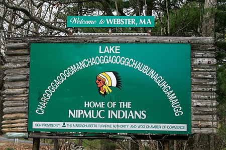
Chaubunagungamaug Reservation

The Chaubunagungamaug Reservation refers to the small parcel of land located in the town of Thompson, Connecticut, close to the border with the town of Webster, Massachusetts and within the bounds of Lake Chaubunagungamaug (Webster Lake) to the east and the French River to the west. The reservation is used by the descendants of the Nipmuck Indians of the previous reservation, c. 1682–1869, that existed in the same area, who now identify as the Webster/Dudley Band of the Chaubunagungamaug Nipmuck. Together with the Hassanamisco Nipmuc, both have received state recognition under the Massachusetts Commission on Indian Affairs.The reservation only consists of 2.5 acres (1.0 hectare), and does not support a permanent population. It does serve as a meeting place and cultural center for Webster/Dudley Band of the Chaubunagungamaug Nipmuck. The land is also used as a place for the reinterment of local Native American remains. The tribe, and its reservation, are recognized in Massachusetts, but both lack recognition in Connecticut and at the federal level.
Excerpt from the Wikipedia article Chaubunagungamaug Reservation (License: CC BY-SA 3.0, Authors, Images).Chaubunagungamaug Reservation
Wagher Road,
Geographical coordinates (GPS) Address Nearby Places Show on map
Geographical coordinates (GPS)
| Latitude | Longitude |
|---|---|
| N 42.024166666667 ° | E -71.877222222222 ° |
Address
Wagher Road 225
06255
Connecticut, United States
Open on Google Maps


