place

Belmont Park station

1905 establishments in New York (state)Belmont ParkLong Island Rail Road stations in New York CityRailway stations in Queens, New YorkRailway stations in the United States opened in 1905
Use mdy dates from September 2019
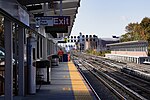
Refurbished Belmont Park Station (18466839521)

Belmont Park is a seasonal-use Long Island Rail Road station on the grounds of the Belmont Park racetrack in the New York City borough of Queens. The station is a terminus of a spur line that lies south of and between the Queens Village and Bellerose stations on the Main Line/Hempstead Branch. Consistent with the names of other lines and branches of the LIRR, the spur line is called the Belmont Park Branch. Train service to the Belmont Park station is operated only for special events such as the Belmont Stakes. Starting in November 2021, the venue has also been served full-time by the Elmont station, located directly to the north and along the Main Line/Hempstead Branch. Unlike the rest of the property on Belmont Park, the Belmont Park station is part of a small sliver of Belmont property (including some parking) that is located in Queens. The racing complex is located in Nassau County.

Excerpt from the Wikipedia article Belmont Park station (License: CC BY-SA 3.0, Authors, Images).

Belmont Park station
Cross Island Parkway, New York Queens County

Geographical coordinates (GPS) Address External links Nearby Places
placeShow on map

Wikipedia: Belmont Park stationContinue reading on Wikipedia

Geographical coordinates (GPS)

Latitude Longitude
N 40.713655 ° E -73.728299 °
placeShow on map

Address

Belmont Park

Cross Island Parkway
11429 New York, Queens County
New York, United States
mapOpen on Google Maps

linkWikiData (Q4884403)
linkOpenStreetMap (7089672831)

Refurbished Belmont Park Station (18466839521)
Share experience

Nearby Places

Belmont Park
Belmont Park

Belmont Park is a thoroughbred horse racetrack in Elmont, New York, United States, just east of the New York City limits. It was opened on May 4, 1905, and is one of the major tracks in the northeastern United States. It is operated by the non-profit New York Racing Association, as are the Aqueduct Racetrack and Saratoga Race Course. The group was formed in 1955 as the Greater New York Association to assume the assets of the individual associations that ran Belmont, Aqueduct, Saratoga, and the now-defunct Jamaica Race Course. Belmont Park is typically open for racing from late April through mid-July (known as the Spring meet), and again from mid-September through late October (the Fall meet). It is widely known as the home of the Belmont Stakes in early June, regarded as the "Test of the Champion", the third leg of the Triple Crown. Along with Saratoga Race Course in Upstate New York, Keeneland and Churchill Downs in Kentucky, and Del Mar and Santa Anita in California, Belmont is considered one of the elite racetracks in North America. The race park's main dirt track has earned the nickname, "the Big Sandy," given its prominent overall dimensions (1+1⁄2 miles (2.4 km)) and the deep, sometimes tiring surface. Belmont is also sometimes known as "The Championship Track" because almost every major champion in racing history since the early 20th century has competed on the racecourse – including all of the Triple Crown winners. Belmont Park, with its big, wide, sweeping turns and long homestretch, is considered one of the fairest racetracks. The Hall of Fame champion Easy Goer graces the cover of the 2005 book, Belmont Park: A Century of Champions, with paintings by Richard Stone Reeves and text by Edward L. Bowen. The book chronicles seventy racehorses who competed from 1905 to 2005 thrilling fans, setting records, and becoming legends at the venerable New York track.Belmont hosted its largest crowd in 2004, when 120,139 saw Smarty Jones upset by Birdstone in his Triple Crown bid.

Springfield Boulevard

Springfield Boulevard is a major north/south roadway that runs through the eastern section of Queens, New York. It is 7.8 miles (12.6 km) long and goes from Northern Boulevard in Bayside, to 147th Avenue in Springfield Gardens. Springfield Boulevard runs through Bayside, Oakland Gardens, Queens Village, Cambria Heights, Laurelton, Springfield Gardens and along the eastern border of St. Albans. The name "Springfield," derived from the Springfield Armory, is one of several firearms-oriented street names in the area. This is the result of the National Rifle Range having been situated on the grounds of what is now Creedmoor State Hospital during the 19th and early 20th centuries. The north end of Springfield Boulevard is a simple two-way two lane street in southeastern Bayside. It gradually gets wider as it heads towards Springfield Gardens. At some time the city widened Springfield Boulevard in Queens Village from 112th Avenue to Jamaica Avenue, in character with its name as a "Boulevard". South of Jamaica Avenue, it gains a strip median used as a turning lane for intersections, and south of 112th Avenue all the way to 147th Avenue, it gains a median divider. The Q1, Q2, Q27, Q77, Q83, Q85 and Q88 bus lines all serve Springfield Boulevard. Springfield Boulevard intersects with many major roads including Northern Boulevard, Union Turnpike, Hillside Avenue, Jamaica Avenue, Hempstead Avenue, Linden Boulevard, Francis Lewis Boulevard and Merrick Boulevard. At its southern end, Springfield Boulevard once continued to Rockaway Boulevard; however, frequent flooding led to that stretch being closed. The land there has been developed into a distribution center. Many high schools are located near Springfield Boulevard, including Springfield Gardens High School, Martin Van Buren High School, and Benjamin Cardozo High School. Queensborough Community College is also located fairly close to Springfield Boulevard in Bayside.