place

Rothley

Borough of CharnwoodCivil parishes in LeicestershireUse British English from July 2015Villages in Leicestershire
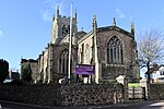
Rothley parish church 2006 04 04 006web

Rothley ( ROHTH-lee) is a village and civil parish within the Borough of Charnwood in Leicestershire, England. Situated around one-half mile (800 metres) west of the River Soar and five miles (eight kilometres) north of Leicester, it had a population of 3,612 inhabitants the 2001 census. The population measured at the 2011 census was 3,897.Rothley centres on two greens, Cross Green and the Town Green, both of which are accessed by a road that leads from the crossroads. The crossroads lies on the old route of the A6 road, which now bypasses the village. Rothley is one of Leicestershire's most affluent areas based on number of houses worth more than £1 million – especially in some streets such as The Ridgeway, identified in the Sunday Times as the most expensive place to live in the East Midlands.Most children of primary schooling age attend Rothley (Church of England) Primary School. The main shopping street in the village is Woodgate. Rothley has four churches, Rothley Baptist Church, the Methodist Church, Sacred Heart RC, and the main parish church St Mary & St John's Church of England. Rothley has close links with its neighbouring village, Mountsorrel, which is two miles (three kilometres) to the north.

Excerpt from the Wikipedia article Rothley (License: CC BY-SA 3.0, Authors, Images).

Rothley
Fowke Street, Charnwood Rothley

Geographical coordinates (GPS) Address Nearby Places
placeShow on map

Wikipedia: RothleyContinue reading on Wikipedia

Geographical coordinates (GPS)

Latitude Longitude
N 52.709 ° E -1.136 °
placeShow on map

Address

Fowke Street

Fowke Street
LE7 7PJ Charnwood, Rothley
England, United Kingdom
mapOpen on Google Maps

Rothley parish church 2006 04 04 006web
Share experience

Nearby Places

River Wreake
River Wreake

The River Wreake is a river in Leicestershire, England. It is a tributary of the River Soar. The river between Stapleford Park and Melton Mowbray is known as the River Eye and becomes the Wreake below Melton Mowbray. It flows southwest, passing through Melton Mowbray, Asfordby, Frisby on the Wreake, Brooksby, Thrussington and Ratcliffe on the Wreake, before meeting the Soar near Syston. In its upper reaches it is called the River Eye and it becomes the Wreake below Melton Mowbray, near Sysonby Lodge. The name Wreake was given by Danish invaders of Leicestershire, who are thought to have navigated the River Trent, then the River Soar and finally the Wreake as they entered the district. Their word Wreake indicated that the river followed a tortuous, twisting and turning course. The river was canalised in the late 18th century, though after the building of the Syston and Peterborough railway in the mid 19th Century, the canal was disused and fell into ruin. Many of the diversions made to the river in order to make the canal navigable are still visible, especially in the neighbourhood of Hoby with Rotherby, Frisby on the Wreake, Kirby Bellars and Asfordby. The Wreake is graded by the Environment Agency as "B" quality, which is excellent for a Midlands river. Biotic index surveys report mayfly and stonefly nymphs, caddis fly larvae, dragonfly and damselfly nymphs and crayfish. Among the fish are Perch, Chubb, Pike, Minnows, Miller's Thumb, and Trout. Otters are starting to repopulate the Wreake in its quieter stretches. Media related to River Wreake at Wikimedia Commons