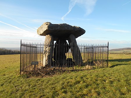
Kit's Coty House

Kit's Coty House or Kit's Coty is a chambered long barrow near the village of Aylesford in the southeastern English county of Kent. Constructed circa 4000 BCE, during the Early Neolithic period of British prehistory, today it survives in a ruined state. Archaeologists have established that the monument was built by pastoralist communities shortly after the introduction of agriculture to Britain from continental Europe. Although representing part of an architectural tradition of long barrow building that was widespread across Neolithic Europe, Kit's Coty House belongs to a localised regional variant of barrows produced in the vicinity of the River Medway, now known as the Medway Megaliths. Of these, it lies near to both Little Kit's Coty House and the Coffin Stone on the eastern side of the river. Three further surviving long barrows, Addington Long Barrow, Chestnuts Long Barrow, and Coldrum Long Barrow, are located west of the Medway. They were among the first ancient British remains to be protected by the state, on the advice of General Augustus Pitt-Rivers, the first Inspector of Ancient Monuments. The site is now under the ownership of non-departmental public body English Heritage, and is open to visitors all year round.Kit's Coty can be reached on foot along a track that appears at the junction where the Pilgrim's Way and Rochester Road meet. The chamber is encircled by iron railings. It lies approximately 2 kilometres north of another of the Medway Megaliths, Little Kit's Coty House.The name "Kits Coty" allegedly means "Tomb in the Forest" according to signs at the site, possibly related to the Ancient British *kaitom, later *keiton, meaning "forest". The site is the namesake of Kitscoty, a village in Alberta, Canada. The inclusion of the term "House" in the site's name has confused some visitors, who have gone to the site expecting a built dwelling.
Excerpt from the Wikipedia article Kit's Coty House (License: CC BY-SA 3.0, Authors, Images).Kit's Coty House
Chatham Road, Tonbridge and Malling Aylesford
Geographical coordinates (GPS) Address Website External links Nearby Places Show on map
Geographical coordinates (GPS)
| Latitude | Longitude |
|---|---|
| N 51.3199285 ° | E 0.5029495 ° |
Address
Kit's Coty House (Kit's Coty;Kits Coty House)
Chatham Road
ME20 7EF Tonbridge and Malling, Aylesford
England, United Kingdom
Open on Google Maps


