Schesaplana
Austria–Switzerland borderGraubünden mountain stubsInternational mountains of EuropeMountains of GraubündenMountains of Switzerland ... and 6 more
Mountains of VorarlbergMountains of the AlpsPages with German IPASeewis im PrättigauTwo-thousanders of SwitzerlandVorarlberg geography stubs

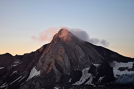
The Schesaplana (German pronunciation: [ʃezaˈplaːna]) is the highest mountain in the Rätikon mountain range at the border between Vorarlberg, Austria and Graubünden, Switzerland. It has an elevation of 2,964.3 m (9,725 ft). On the north side of the Schesaplana is a glacier called Brandner Gletscher. To the east is the Lünersee. It is possible to reach the summit on various routes during a hike, making it useful for a multiday trek between the mountain huts in the area. A more horizontal trek is following the whole of the Rätikon chain along its southern face, called "Prättigauer Höhenweg".
Excerpt from the Wikipedia article Schesaplana (License: CC BY-SA 3.0, Authors, Images).Schesaplana
Schweizersteig,
Geographical coordinates (GPS) Address Nearby Places Show on map
Geographical coordinates (GPS)
| Latitude | Longitude |
|---|---|
| N 47.053888888889 ° | E 9.7072222222222 ° |
Address
Schweizersteig
7215
Grisons, Switzerland
Open on Google Maps


