place

Hammels, Queens

AC with 0 elementsNeighborhoods in Rockaway, QueensPopulated coastal places in New York (state)Queens, New York geography stubs
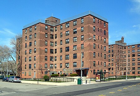
Hammel NYCHA jeh
Hammel NYCHA jeh

Hammels is an area within Rockaway Beach on the Rockaway Peninsula in the New York City borough of Queens. It is located west of Arverne and east of Seaside, and is centered on Beach 84th Street. Its main thoroughfare is Beach Channel Drive. The New York City Subway's A train travels through the neighborhood on the IND Rockaway Line. The Hammel Houses, a public housing project built in 1954, is located in the neighborhood.

Excerpt from the Wikipedia article Hammels, Queens (License: CC BY-SA 3.0, Authors, Images).

Hammels, Queens
Rockaway Beach Boulevard, New York Queens County

Geographical coordinates (GPS) Address Nearby Places
placeShow on map

Wikipedia: Hammels, QueensContinue reading on Wikipedia

Geographical coordinates (GPS)

Latitude Longitude
N 40.587777777778 ° E -73.808055555556 °
placeShow on map

Address

Rockaway Beach Boulevard & Beach 81st Street

Rockaway Beach Boulevard
11694 New York, Queens County
New York, United States
mapOpen on Google Maps

Hammel NYCHA jeh
Hammel NYCHA jeh
Share experience

Nearby Places

Rockaway Beach and Boardwalk

The Rockaway Beach and Boardwalk is a public park in Rockaway, Queens, New York, composed of the 170-acre (69 ha) Rockaway Beach and the adjacent 5.5-mile (8.9 km) Rockaway Boardwalk, which is also the longest boardwalk in the US. The beach runs from Beach 9th Street in Far Rockaway to Beach 149th Street in Neponsit, a distance of 7 miles (11 km). The boardwalk, a concrete deck, runs from Beach 9th Street to Beach 126th Street in Rockaway Park, at the edge of Belle Harbor. There are also numerous recreational facilities within the park, parallel to the beach and boardwalk. The beach became a popular resort area in the late 19th century, and several disconnected sections of the boardwalk were constructed by the end of the century. The first section of city-owned boardwalk between Beach 109th and 126th Street was completed in 1923, and the city announced plans for a massive boardwalk two years later, stretching across most of the Rockaway peninsula's southern shore. The city government completed the sections between Beach 19th and 109th Streets in three phases between 1928 and 1930. The concrete boardwalk from Beach 9th Street to Beach 19th Street was completed in 1963. After Hurricane Sandy destroyed much of the boardwalk in 2012, it was rebuilt in several phases through 2017. The park has been maintained by the New York City Department of Parks and Recreation since 1938. It is policed by the New York City Parks Enforcement Patrol.

Kohlreiter Square
Kohlreiter Square

Kohlreiter Square is an 8.6-acre public green space located in the Arverne neighborhood on Rockaway Peninsula in Queens, New York. It located along the north side of Rockaway Freeway between Beach 67th and Beach 69th Streets. The park honors two generations of civic activists, Nathan A. Kohlreiter (1880–1961) and his son Fred Kohlreiter (1913–1990) who contributed to the political and social fabric of the neighborhood. Kohlreiter Square dates to the early twentieth century, when it served as a plaza to the Arverne – Gaston Avenue Long Island Railroad (LIRR) station. The station opened in 1887, shortly before the completion of Arverne-By-The-Sea, a community of upscale summer homes and hotels along the beach. The neighborhood’s name is an abbreviation of its developer’s name, Remington R. Vernam. The tracks were elevated in 1942, with the Rockaway Freeway running beneath them. As part of a grade elimination project, undeveloped and condemned properties along the Freeway were acquired by the city as parkland. The station plaza was acquired from the LIRR in 1946. In 2001 construction commenced on a new residential community that revived the name Arverne-by-the-Sea. Comprising single and multi-family homes to the south of Rockaway Freeway, it includes a retail plaza on the southern side of the subway station, adjoining Kohlreiter Square. Before 2001, there was a Joseph P. Addabbo Family Health Center on the southern side of the 67th street subway station, and a synagogue across the street from the health center. The synagogue burned down in 2001, and the family health center moved to a new building on Beach 62nd street after it was built in 2005. The old building was torn down in 2006 during the construction of the retail plaza.