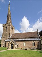
Oxton, Nottinghamshire
EngvarB from May 2016Newark and SherwoodNottinghamshire geography stubsPages containing London Gazette template with parameter supp set to yVillages in Nottinghamshire

Oxton is a village in Nottinghamshire, England, with a 568 residents at the 2011 census. It is located 5 miles west of Southwell, 5 miles north of Lowdham, 10 miles NE of Nottingham and 2 miles NE of Calverton, and lies on the B6386, and is very close to the A6097 trunk road. Oxton has a church dedicated to St Peter & St Paul; a post office and two pubs. Oxton also has two fords – a small ford within the village itself, and a much larger ford on Beanford Lane – often as deep as 1 ft whilst remaining open to all traffic. It is however closed each March, so that the toads found in the swamp-like area, which the ford crosses, can breed.
Excerpt from the Wikipedia article Oxton, Nottinghamshire (License: CC BY-SA 3.0, Authors, Images).Oxton, Nottinghamshire
Church View, Newark and Sherwood
Geographical coordinates (GPS) Address Nearby Places Show on map
Geographical coordinates (GPS)
| Latitude | Longitude |
|---|---|
| N 53.056 ° | E -1.062 ° |
Address
Church View
Church View
NG25 0TF Newark and Sherwood
England, United Kingdom
Open on Google Maps


