Duxbury Beach

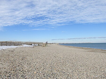
Duxbury Beach is a barrier beach in the town of Duxbury, Massachusetts. It is six miles long and is accessed by the Powder Point Bridge from Duxbury, or Gurnet Road from Marshfield. Since 1975, approximately 4.5 miles of the beach is owned by Duxbury Beach Reservation, Inc, which annually leases a substantial portion of the beach—excepting the Duxbury Beach Park area—to the town of Duxbury. Under this arrangement, the town issues beach vehicle permits, provides police protection, and provides conservation officers to patrol the beach in all seasons of the year.It is 50 yards wide at some points, and is the sole land access to the villages of Saquish and Gurnet Point across the town line in Plymouth, the only land area where the two towns meet. The northern residential end is protected by an Army Corps Of Engineers concrete seawall. The beach is near Plymouth Light and the remains of the Civil War Fort Andrew and Fort Standish. Fort Andrew was preceded by Gurnet Fort in the Revolutionary War. It is only accessible when the lighthouse has an open house for visitors.
Excerpt from the Wikipedia article Duxbury Beach (License: CC BY-SA 3.0, Authors, Images).Duxbury Beach
Powder Point Avenue,
Geographical coordinates (GPS) Address Nearby Places Show on map
Geographical coordinates (GPS)
| Latitude | Longitude |
|---|---|
| N 42.041769444444 ° | E -70.635591666667 ° |
Address
Duxbury Beach Reservation
Powder Point Avenue
02332
Massachusetts, United States
Open on Google Maps


