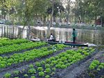
Chinampa (Nahuatl languages: chināmitl [tʃiˈnaːmitɬ]) is a technique used in Mesoamerican agriculture which relies on small, rectangular areas of fertile arable land to grow crops on the shallow lake beds in the Valley of Mexico. They are built up on wetlands of a lake or freshwater swamp for agricultural purposes, and their proportions ensure optimal moisture retention. The United Nations designated it a Globally Important Agricultural Heritage System in 2018. The Aztecs created the very first Chinampa.
Although different technologies existed during the Post-classic and Colonial periods in the basin, chinampas have raised many questions on agricultural production and political development. After the Aztec Triple Alliance formed, the conquest of southern basin city-states, such as Xochimilco, was one of the first strategies of imperial expansion. Before this time, farmers maintained small-scale chinampas adjacent to their households and communities in the freshwater lakes of Xochimilco and Chalco. Chinampas were invented by the Aztec civilization. Sometimes referred to as "floating gardens," chinampas are artificial islands that were created by interweaving reeds with stakes beneath the lake's surface, creating underwater fences. A buildup of soil and aquatic vegetation would be piled into these "fences" until the top layer of soil was visible on the water's surface.When creating chinampas, in addition to building up masses of land, a drainage system was developed. This drainage system was multi-purposed. A ditch was created to allow for the flow of water and sediments (likely including night soil). Over time, the ditch would slowly accumulate piles of mud. This mud would then be dug up and placed on top of the chinampas, clearing the blockage. The soil from the bottom of the lake was also rich in nutrients, thus acting as an efficient and effective way of fertilizing the chinampas. Replenishing the topsoil with lost nutrients provided for bountiful harvests. Embarcadero-Jiménez and colleagues tested the correlation between environmental parameters and bacterial diversity in the soil. It is speculated that a diverse array of bacteria can affect the nutrients in the soil. The results found that bacterial diversity was more abundant in cultivated soils than non-cultivated soils. Also, "the structure of the bacterial communities showed that the chinampas are a transition system between sediment and soil and revealed an interesting association of the S-cycle and iron-oxidizing bacteria with the rhizosphere of plants grown in the chinampa soil".Evidence from Nahuatl wills from late seventeenth-century Pueblo Culhuacán suggests chinampas were measured in matl (one matl = 1.67 meters), often listed in groups of seven. One scholar has calculated the size of chinampas using Codex Vergara as a source, finding that they usually measured roughly 30 m × 2.5 m (100 ft × 10 ft). In Tenochtitlan, the chinampas ranged from 90 m × 5 m (300 ft × 20 ft) to 90 m × 10 m (300 ft × 30 ft) They were created by staking out the shallow lake bed and then fencing in the rectangle with wattle. The fenced-off area was then layered with mud, lake sediment, and decaying vegetation, eventually bringing it above the level of the lake. Often trees such as āhuexōtl [aːˈweːʃoːt͡ɬ] (Salix bonplandiana) (a willow) and āhuēhuētl [aːˈweːweːt͡ɬ] (Taxodium mucronatum) (a cypress) were planted at the corners to secure the chinampa. In some places, the long raised beds had ditches in between them, giving plants continuous access to water and making crops grown there independent of rainfall. Chinampas were separated by channels wide enough for a canoe to pass. These raised, well-watered beds had very high crop yields with up to 7 harvests a year. Chinampas were commonly used in pre-colonial Mexico and Central America. There is evidence that the Nahua settlement of Culhuacan, on the south side of the Ixtapalapa peninsula that divided Lake Texcoco from Lake Xochimilco, constructed the first chinampas in C.E. 1100.

 Continue reading on Wikipedia