Audubon, New Orleans

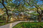
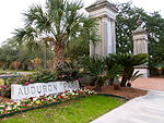
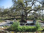
Audubon is a neighborhood of the city of New Orleans. A subdistrict of the Uptown/Carrollton Area, its boundaries as defined by the New Orleans City Planning Commission are: South Claiborne Avenue to the north, Jefferson Avenue to the east, the Mississippi River and Magazine Street to the south, and Lowerline Street to the west. The name Audubon comes from Audubon Park, one of the largest parks in the city, which is located in the southern portion of the district. The area is also known as the "University District," as it is also home of Tulane and Loyola Universities, as well as the former St. Mary’s Dominican College (now a satellite campus of Loyola), and Newcomb College (now part of Tulane). The Audubon neighborhood was also the home of the original campus of Leland University. The section of the neighborhood upriver from Audubon Park incorporates what was the town of Greenville, Louisiana until it was annexed to New Orleans in the 19th century; locals still sometimes call that area "Greenville".
Excerpt from the Wikipedia article Audubon, New Orleans (License: CC BY-SA 3.0, Authors, Images).Audubon, New Orleans
Calhoun Street, New Orleans Greenville
Geographical coordinates (GPS) Address Website Nearby Places Show on map
 Continue reading on Wikipedia
 Geographical coordinates (GPS)
| Latitude | Longitude |
|---|---|
| N 29.933055555556 ° | E -90.120833333333 ° |
Address
Loyola University
Calhoun Street
70118 New Orleans, Greenville
Louisiana, United States
Open on Google Maps
Website
loyno.edu