place

Nettleton's Addition Historic District

Historic districts on the National Register of Historic Places in Washington (state)National Register of Historic Places in Spokane, WashingtonNational Register of Historic Places in Spokane County, WashingtonUse mdy dates from April 2024
Nettleton's Addition Sign

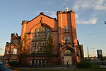
The Nettleton's Addition Historic District is a historic residential district in the West Central neighborhood of Spokane, Washington. It was listed on the National Register of Historic Places (NRHP) in 2006 because of the concentration of historic homes in one of Spokane's oldest residential neighborhoods and for its significance as an example of community planning and development and in the area of architecture. It is the largest national historic district in the state of Washington. Located on a flat plateau surrounded on three sides by a bend in the Spokane River about a mile-and-a-half northwest of the center of Downtown Spokane, the area's proximity to the city center made it one of the first residential areas developed in Spokane. The neighborhood was platted in 1887 and largely developed by 1911. Architectural styles represented in the district include Queen Anne Revival, shingle style, Colonial Revival, Tudor Revival, Bungalow, American Craftsman, as well as a dozen ranch-style homes which were built after 1937 and are not considered to be contributing properties to the historic district. At the time of its listing on the NRHP in 2006, Nettleton's Addition consisted of 949 properties on 1002 parcels, of which 536 are considered to be historic contributing buildings. Notable architects who worked in the neighborhood include Kirtland Cutter and Karl Malmgren. A working and middle-class neighborhood from the time of its development through to the present day, Nettleton's Addition consists primarily of one-to-two story single-family homes built of wood. Nettleton's Addition was laid out in a grid pattern with sidewalks on every street and alleys running east-to-west in the middle of each block. The only disruptions to this pattern come in the northern and southwestern edges of the district where the terrain drops off dramatically to the river and in one block in the northeastern portion of the district where the Holmes Elementary campus takes up the entire block.

Excerpt from the Wikipedia article Nettleton's Addition Historic District (License: CC BY-SA 3.0, Authors, Images).

Nettleton's Addition Historic District
West Gardner Avenue, Spokane

Geographical coordinates (GPS) Address Nearby Places
placeShow on map

Wikipedia: Nettleton's Addition Historic DistrictContinue reading on Wikipedia

Geographical coordinates (GPS)

Latitude Longitude
N 47.667111111111 ° E -117.44852777778 °
placeShow on map

Address

West Gardner Avenue 2501
99201 Spokane
Washington, United States
mapOpen on Google Maps

Nettleton's Addition Sign
Share experience

Nearby Places

Latah Creek
Latah Creek

Latah Creek ( LAY-tə), also known as Hangman Creek, is a large stream in eastern Washington and north central Idaho in the United States. The creek flows northwest from the Rocky Mountains to Spokane, where it empties into the Spokane River. It drains 673 square miles (1,740 km2) in parts of Benewah and Kootenai counties in Idaho, Spokane County and a small portion of Whitman County in Washington, where over 64 percent of its watershed resides. Some major tributaries of the approximately 60-mile (97 km) creek include Little Latah Creek (also known as Little Hangman Creek) and Rock Creek. The average flow of the creek can range from 20 cubic feet per second (0.57 m3/s) to 20,000 cubic feet per second (570 m3/s). Latah Creek receives its name from a Nez Perce word likely meaning "fish". In 1854, the creek received another name, Hangman Creek, from a war between the Palouse Indians and white soldiers, which resulted in several Palouse being hanged alongside the creek. The Latah Creek watershed is dominated by agriculture, which has released large amounts of sediment from the surrounding Palouse soils into the watershed on an annual basis. This has caused the ruin of natural fish populations, riparian zones, and natural flow patterns. The creek has been channelized in some places, and meanders, islands and natural channel formations have been destroyed. In response to these damaging factors, the water quality overall in the Latah Creek basin is quite low, and "Washington State water quality standards for temperature, dissolved oxygen, pH, and fecal coliforms are routinely violated." The remaining third of the land in the watershed is mostly forest.

Peaceful Valley Historic District

The Peaceful Valley Historic District is a National Register of Historic Places-listed historic district in the Peaceful Valley neighborhood of Spokane, Washington. It is located in the western half of the neighborhood, along the floor and southern slope of the Spokane River Gorge, immediately south of the Spokane River and downhill, just below Downtown Spokane. It is centered on the intersection of Main Avenue and Maple Street, stretching from there approximately two blocks in each direction. A residential area, Peaceful Valley was one of the first areas developed in the City of Spokane and was deemed historically significant as an intact example of a working-class neighborhood from the turn of the 20th century. Unlike many other historic districts around the city and state, Peaceful Valley does not represent the moneyed-elite whose grand homes and buildings have been preserved but rather homes of the working class laborers who helped built Spokane throughout its early decades. Located in a steep valley just downstream of Spokane Falls and immediately below the city center which lies on the flat land at the top of the valley to the south and east. This location, isolated by the river and deep gorge, have helped preserve Peaceful Valley's architectural character into the 21st cenutry, though some construction projects such as the Maple Street Bridge which was constructed over the area in the late 1950s have slightly altered the appearance in places, though not the overall cohesion, of the district.