place

Patsy Clark Mansion

Buildings and structures in Spokane, WashingtonHouses completed in 1898Houses in Spokane County, WashingtonHouses on the National Register of Historic Places in Washington (state)Kirtland Cutter buildings
National Register of Historic Places in Spokane, WashingtonWashington (state) Registered Historic Place stubsWashington (state) building and structure stubs
Patsy Clark House (Spokane, WA) (2877645119)

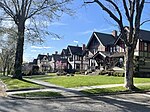
The Patsy Clark Mansion is a Spokane, Washington, United States, residence that was designed by architect Kirtland Cutter in 1897 for mining millionaire Patsy Clark. It is located at 2208 West Second Avenue in the city's historic Browne's Addition. The mansion had long been used as a restaurant. In 2002, a law firm purchased the mansion for $1.03 million in order to rescue the landmark from further deterioration. The mansion now houses a law firm, while still remaining open for private rentals for small events. It was listed on the National Register of Historic Places as Clark Mansion in 1975. It is included also as a contributing property in Browne's Addition Historic District.

Excerpt from the Wikipedia article Patsy Clark Mansion (License: CC BY-SA 3.0, Authors, Images).

Patsy Clark Mansion
West Pacific Avenue, Spokane

Geographical coordinates (GPS) Address Nearby Places
placeShow on map

Wikipedia: Patsy Clark MansionContinue reading on Wikipedia

Geographical coordinates (GPS)

Latitude Longitude
N 47.655277777778 ° E -117.44416666667 °
placeShow on map

Address

Pacific @ Hemlock (MAC Museum)

West Pacific Avenue
99201 Spokane
Washington, United States
mapOpen on Google Maps

Patsy Clark House (Spokane, WA) (2877645119)
Share experience

Nearby Places

High Bridge (Latah Creek)

High Bridge, a railroad bridge over Latah Creek in Spokane, Washington, was constructed in 1972 by the Burlington Northern Railroad, following that railroad's creation in 1970 through the merger of the Chicago, Burlington & Quincy, Great Northern, Northern Pacific, and Spokane, Portland & Seattle railways. The bridge links the former Northern Pacific mainline with the former Great Northern and Spokane, Portland & Seattle lines to the west. The Latah Creek railroad bridge and two bridges carrying Interstate 90 and Sunset Highway cross High Bridge Park and the Latah/Hangman neighborhood of Spokane from Downtown Spokane on the east into the West Hills and Grandview/Thorpe neighborhoods to the west. The bridge is 3,950 feet (1,200 m) long, and its piers reach up to 175 feet (53 m) from the Latah Creek canyon floor. It is constructed of six weathering high-strength steel 160-foot-long (49 m) box girders spans bridging the canyon itself, with adjacent spans from 80 to 100 feet (24 to 30 m), supported by concrete piers. A ballasted concrete deck slab supports the railroad track. The western end of the bridge splits to form a wye.Although not the architect on record, Warren C. Heylman is said to have been the architect behind the design of the bridge, writing Burlington Northern with his "free and unsolicited" advice after he saw the initial plans for the bridge over Hangman valley that was to replace the downtown rail line they had removed in preparation for Expo '74, saying he had to act after seeing their heavily trellised design that would have obscured the historic arches of the Latah Creek Bridge. Heylman never heard back from the railroad company, but says that bridge that was built, a much simpler design with long concrete legs that complemented the nearby I-90 bridge was his. According to the opinion of Washington State University architecture and engineering professor, David Scott, the bridge is arguably Heylman's best work, saying it is "one of the finest examples of what a railroad bridge can look like or be."

Peaceful Valley Historic District

The Peaceful Valley Historic District is a National Register of Historic Places-listed historic district in the Peaceful Valley neighborhood of Spokane, Washington. It is located in the western half of the neighborhood, along the floor and southern slope of the Spokane River Gorge, immediately south of the Spokane River and downhill, just below Downtown Spokane. It is centered on the intersection of Main Avenue and Maple Street, stretching from there approximately two blocks in each direction. A residential area, Peaceful Valley was one of the first areas developed in the City of Spokane and was deemed historically significant as an intact example of a working-class neighborhood from the turn of the 20th century. Unlike many other historic districts around the city and state, Peaceful Valley does not represent the moneyed-elite whose grand homes and buildings have been preserved but rather homes of the working class laborers who helped built Spokane throughout its early decades. Located in a steep valley just downstream of Spokane Falls and immediately below the city center which lies on the flat land at the top of the valley to the south and east. This location, isolated by the river and deep gorge, have helped preserve Peaceful Valley's architectural character into the 21st cenutry, though some construction projects such as the Maple Street Bridge which was constructed over the area in the late 1950s have slightly altered the appearance in places, though not the overall cohesion, of the district.

Ninth Avenue Historic District

The Ninth Avenue Historic District is a National Register of Historic Places (NRHP) listed historic district located along and around Ninth Avenue in the Cliff/Cannon neighborhood of Spokane, Washington. It stretches from Monroe Street on the east to Chestnut Street on the west, running the length of Ninth Avenue and extending to include portions of Eighth, 10th and 11th Avenues, mostly in the western half of the district. A residential area, the district was built to house many of early-Spokane's elite residents in grand Queen Anne, Colonial Revival, Classical Revival, American Foursquare and Tudor Revival homes, along with numerous Bungalow homes for middle-class residents. The area was developed largely between 1892 and 1940, with limited modern incursions in the form of apartments having been built in the decades since. It retains its residential character to this day, though many of the large single-family homes have been converted into multi-unit dwellings. Located roughly one mile from the heart of Downtown Spokane, the Ninth Avenue Historic District is an example of an early residential development in Spokane, free of commercial incursions. Notable architects including Kirtland Cutter, Willis Ritchie, Julius Zittel, Loren L. Rand, John K. Dow and Albert Held designed homes in the district. In the present day, the area is part of the Cliff/Cannon neighborhood of Spokane, stretching from the historic Cannon's Addition in the west over to Monroe Street, a major arterial extending from the north side of Spokane through downtown and up onto the South Hill, in the east. It makes up part of what is now known as the "lower South Hill" for its location near the bottom of a hill which rises abruptly from the downtown area to the north. The terrain surrounding the Ninth Avenue Historic District falls off dramatically on the west to a valley containing Latah Creek, which marks a natural western boundary, and drops to the north to the valley of the Spokane River and Downtown Spokane in the north, while terrain rises to the west and south as one continues up into the South Hill residential area of Spokane.