place

Browne's Addition, Spokane

Geography of Spokane, WashingtonNeighborhoods in Spokane, Washington
Campbell House Spokane 2018

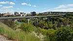
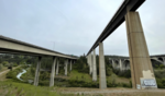
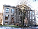
Browne's Addition, often referred to shorthand as just Browne's, is a neighborhood in Spokane, Washington. It is located directly west of Downtown Spokane and is one of the oldest and densest neighborhoods in the city. The area is known for its numerous historic mansions, many of which have been converted into multi-family apartments. The terrain is flat in the neighborhood despite the degree of topographical relief in the immediate surrounding area. Latah Creek cuts a deep valley to the west, separating Browne's Addition from the Sunset Hill portion of the West Hills neighborhood and the Spokane River gorge drops off dramatically to the north into the Peaceful Valley neighborhood. The South Hill area of Spokane rises to the southwest. Browne's Addition is known as one of Spokane's centers of culture, with its collection of historic structures, vibrant culinary and nightlife scene, numerous community festivals, and for being the location of the Northwest Museum of Arts and Culture.

Excerpt from the Wikipedia article Browne's Addition, Spokane (License: CC BY-SA 3.0, Authors, Images).

Browne's Addition, Spokane
Spokane

Geographical coordinates (GPS) Address Nearby Places
placeShow on map

Wikipedia: Browne's Addition, SpokaneContinue reading on Wikipedia

Geographical coordinates (GPS)

Latitude Longitude
N 47.655555555556 ° E -117.44161111111 °
placeShow on map

Address


99201 Spokane
Washington, United States
mapOpen on Google Maps

Campbell House Spokane 2018
Share experience

Nearby Places

Peaceful Valley Historic District

The Peaceful Valley Historic District is a National Register of Historic Places-listed historic district in the Peaceful Valley neighborhood of Spokane, Washington. It is located in the western half of the neighborhood, along the floor and southern slope of the Spokane River Gorge, immediately south of the Spokane River and downhill, just below Downtown Spokane. It is centered on the intersection of Main Avenue and Maple Street, stretching from there approximately two blocks in each direction. A residential area, Peaceful Valley was one of the first areas developed in the City of Spokane and was deemed historically significant as an intact example of a working-class neighborhood from the turn of the 20th century. Unlike many other historic districts around the city and state, Peaceful Valley does not represent the moneyed-elite whose grand homes and buildings have been preserved but rather homes of the working class laborers who helped built Spokane throughout its early decades. Located in a steep valley just downstream of Spokane Falls and immediately below the city center which lies on the flat land at the top of the valley to the south and east. This location, isolated by the river and deep gorge, have helped preserve Peaceful Valley's architectural character into the 21st cenutry, though some construction projects such as the Maple Street Bridge which was constructed over the area in the late 1950s have slightly altered the appearance in places, though not the overall cohesion, of the district.

High Bridge (Latah Creek)

High Bridge, a railroad bridge over Latah Creek in Spokane, Washington, was constructed in 1972 by the Burlington Northern Railroad, following that railroad's creation in 1970 through the merger of the Chicago, Burlington & Quincy, Great Northern, Northern Pacific, and Spokane, Portland & Seattle railways. The bridge links the former Northern Pacific mainline with the former Great Northern and Spokane, Portland & Seattle lines to the west. The Latah Creek railroad bridge and two bridges carrying Interstate 90 and Sunset Highway cross High Bridge Park and the Latah/Hangman neighborhood of Spokane from Downtown Spokane on the east into the West Hills and Grandview/Thorpe neighborhoods to the west. The bridge is 3,950 feet (1,200 m) long, and its piers reach up to 175 feet (53 m) from the Latah Creek canyon floor. It is constructed of six weathering high-strength steel 160-foot-long (49 m) box girders spans bridging the canyon itself, with adjacent spans from 80 to 100 feet (24 to 30 m), supported by concrete piers. A ballasted concrete deck slab supports the railroad track. The western end of the bridge splits to form a wye.Although not the architect on record, Warren C. Heylman is said to have been the architect behind the design of the bridge, writing Burlington Northern with his "free and unsolicited" advice after he saw the initial plans for the bridge over Hangman valley that was to replace the downtown rail line they had removed in preparation for Expo '74, saying he had to act after seeing their heavily trellised design that would have obscured the historic arches of the Latah Creek Bridge. Heylman never heard back from the railroad company, but says that bridge that was built, a much simpler design with long concrete legs that complemented the nearby I-90 bridge was his. According to the opinion of Washington State University architecture and engineering professor, David Scott, the bridge is arguably Heylman's best work, saying it is "one of the finest examples of what a railroad bridge can look like or be."