place

Stößensee Bridge

1900s architectureBridges in BerlinRoad bridges in GermanySteel bridgesSteel bridges in Germany
Stoessensee B Westend 07 2017 img2

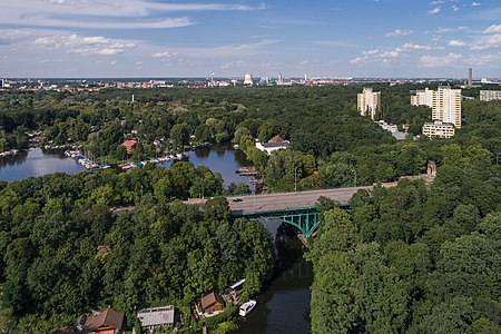
The Stößenseebrücke is a steel truss bridge over the Stößensee and the Havelchaussee in the Berlin district of Spandau. The listed bridge from 1908/1909 is part of Heerstraße (federal highway 2/5) and connects the Spandau district of Wilhelmstadt with the Westend district of Charlottenburg-Wilmersdorf. The biggest technical and financial problem during the construction of the Heerstraße was bridging the Havel lowland, which includes the Stößensee, an old arm of the Havel. From several options, including an additional 250-meter-long bridge over the Scharfe Lanke, the planners opted for a route that could manage with two bridges - over the Havel and the Stößensee. With regard to the variants of the Stößensee bridge, the "small" solution with a dam embankment and a bridge around 100 meters long was chosen instead of a bridge over the entire lake. The bridge consists of a system of cantilever girders with connected towing girders and has a span of around 50 meters. It was designed by civil engineer Karl Bernhard.

Excerpt from the Wikipedia article Stößensee Bridge (License: CC BY-SA 3.0, Authors, Images).

Stößensee Bridge
Heerstraße, Berlin Wilhelmstadt

Geographical coordinates (GPS) Address External links Nearby Places
placeShow on map

Wikipedia: Stößensee BridgeContinue reading on Wikipedia

Geographical coordinates (GPS)

Latitude Longitude
N 52.509166666667 ° E 13.214722222222 °
placeShow on map

Address

Stößenseebrücke

Heerstraße
13595 Berlin, Wilhelmstadt
Germany
mapOpen on Google Maps

linkWikiData (Q2360818)
linkOpenStreetMap (376730239)

Stoessensee B Westend 07 2017 img2
Share experience

Nearby Places

Tiefwerder
Tiefwerder

Tiefwerder encompasses both a village and a Werder along the Havel River in the Berlin district of Spandau. While the village of Tiefwerder, along with the neighboring southern port of Spandau, falls under the jurisdiction of the district of Spandau, the surrounding forested areas, meadows, and water areas of the Werder are administratively part of the district of Wilhelmstadt. An early Slavic settlement existed at Faulen See until the 13th century. The village of Tiefwerder was established as a colonist village in 1815. It was during this time that descendants of the Spandau Kietz fishermen were resettled on the Werder. Today, a significant portion of the historic houses lining the village street has been preserved and is recognized as the entire ensemble of the colonist settlement Tiefwerder. The building at Dorfstraße 5 from 1895, which has been home to the Ballhaus Spandau since the 1920s, is also a listed building. Additionally, the Tiefwerder waterworks, built in 1914, played a crucial role by supplying drinking water to six Berlin districts. To the south and east, the village of Tiefwerder is bordered by the Tiefwerder Wiesen landscape conservation area. This area, intersected by ancient arms of the Havel River, stands as Berlin's last preserved natural floodplain and a crucial spawning ground for pike, contributing significantly to species protection efforts. It boasts a diverse landscape, featuring wet meadows, remnants of floodplain forests, and reed beds with natural land-water transitions. Due to the numerous watercourses and settlements along the ditches, Tiefwerder is also known as the "Little Venice of Spandau".

Murellen mountains, Murellen gorge and Schanzenwald forest

The Murellenberge, the Murellenschlucht and the Schanzenwald are a hilly landscape formed during the Weichselian Ice Age in the Berlin district of Ruhleben in the Westend part of the District of Charlottenburg-Wilmersdorf. The area is located to the west of the Olympic site. The largest part of the upslope and terminal moraine landscape is designated as nature reserve Murellenschlucht und Schanzenwald, which is part of the biotope network Fließwiese Ruhleben, Tiefwerder Wiesen and Grunewald. About 1.5 kilometers northeast of the area (from Murellenberg) is the natural monument Murellenteich. The Murellenberge (often referred to as 'Murellenberg', formerly: Morellenberge) are part of the Teltownordband, which forms the northernmost spur of the Teltow plateau to the Berliner Urstromtal. The connection of the original natural area was largely lost due to urban development. The up to 62 meter high mountains and the up to 30 meter incised basin have a diverse and endangered flora and fauna, especially in their dry grassland areas. Used as a military and police area for over 150 years, the forest stands in the Schanzenwald were able to develop almost undisturbed. The Waldbühne was built in the eastern part of the ravine in 1936 under the direction of the architect Werner March. The National Socialists set up an execution site in the mountains for deserters and so-called "wehrkraftzersetzer". The Installation Memorial to the Murdered by Nazi Military Justice on the Murellenberg by the artist Patricia Pisani from 2002 commemorates the victims.