place

Hampden County, Massachusetts
1812 establishments in Massachusetts1998 disestablishments in MassachusettsHampden County, MassachusettsMassachusetts countiesPopulated places disestablished in 1998
Populated places established in 1812Populated places in Hampden County, MassachusettsSpringfield metropolitan area, MassachusettsUse mdy dates from September 2017
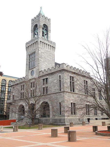
Hampden County Courthouse DSC03264

Hampden County is a non-governmental county located in the Pioneer Valley of the state of Massachusetts, in the United States. As of the 2020 census, Hampden County's population was 465,825. Its traditional county seat is Springfield, the Connecticut River Valley's largest city, and economic and cultural capital; with an estimated population of 154,758, approximately 1 in 3 residents of Hampden County live in Springfield. Hampden County was split from Hampshire County in 1812, because Northampton, Massachusetts, was made Hampshire County's "shire town" in 1794; however, Springfield—theretofore Hampshire County's traditional shire town, dating back to its founding in 1636—grew at a pace far quicker than Northampton and was granted shire town-status over its own, southerly jurisdiction. It was named for parliamentarian John Hampden. To the north of Hampden County is modern-day Hampshire County; to the west is Berkshire County; to the east is Worcester County; to the south are Litchfield County, Hartford County, and Tolland County in Connecticut. Hampden County is part of the Springfield, MA Metropolitan Statistical Area. It is the most urban county in Western Massachusetts. The Knowledge Corridor surrounding Springfield-Hartford is New England's second most populous urban area (after Greater Boston) with 1.9 million people.

Excerpt from the Wikipedia article Hampden County, Massachusetts (License: CC BY-SA 3.0, Authors, Images).

Hampden County, Massachusetts
Border Way,

Geographical coordinates (GPS) Address Nearby Places
placeShow on map

Wikipedia: Hampden County, MassachusettsContinue reading on Wikipedia

Geographical coordinates (GPS)

Latitude Longitude
N 42.14 ° E -72.63 °
placeShow on map

Address

Border Way 64
01089
Massachusetts, United States
mapOpen on Google Maps

Hampden County Courthouse DSC03264
Share experience

Nearby Places

Cabotville Common Historic District

The Cabotville Common Historic District is a predominantly residential historic district in Chicopee, Massachusetts. It is centered on the park now called Lucy Wisniowski Park, which was previously known as "The Common", and includes all of the buildings that face the park, as well as a few on immediately adjacent city streets. It was developed in the 1830s and 1840s as an area where mid-level employees of Chicopee's mills and factories lived, between the simpler tenements and boarding houses of the lower classes, and the elite mansions of the proprietors and top-level managers. Most of the building stock in the district was built between 1846 and 1870, and were single family brick or wood-frame Greek Revival houses. The Common, whose original purpose was to provide shared pasturage for area residents, was by the end of this period converted to a park. From the 1870s to the 1890s the housing stock was predominantly multi-family in scale, and exhibited the architectural fashions of the time: Italianate, Second Empire, and Victorian. Thereafter development was limited due to a lack of available land, and only a few brick apartment houses were built between 1890 and 1915.Since that time there have been only modest changes to the neighborhood. A school was torn down, and was replaced by a wading pool and bath house. Buildings have been altered and added, and a few have been moved. The district was listed on the National Register of Historic Places in 1989.

Chicopee, Massachusetts

Chicopee ( CHIK-ə-pee) is a city located on the Connecticut River in Hampden County, Massachusetts, United States. As of the 2020 census, the city had a population of 55,560, making it the second-largest city in Western Massachusetts after Springfield. Chicopee is part of the Springfield, Massachusetts Metropolitan Statistical Area. The communities of Chicopee Center (Cabotville), Chicopee Falls, Willimansett, Fairview, Aldenville, Burnett Road, Smith Highlands and Westover are located within the city. One of the ventures of the Boston Associates, Chicopee is a city built around several smaller former mill communities on its namesake, the Chicopee River. During the 19th century, the city was home to the first American producer of friction matches as well as a variety of other industries, including the Ames Manufacturing Company, an early pioneer in machining lathes, building upon the work of Springfield's Thomas Blanchard, and the largest producer of swords and cutlasses for the Union Army during the Civil War. By the start of the 20th century, the city was home to a number of industrial plants, including those of the Fisk Tire Company, one of the largest tire makers of that time, and some of the earliest sporting goods factories of A. G. Spalding.Today the city is home to a variety of specialty manufacturers, as well as Westover Air Reserve Base, the largest Air Force Reserve Base of the United States, built in 1940 with the emergence of World War II. Chicopee today goes by the nickname the "Crossroads of New England" as part of a business-development marketing campaign, one that West Springfield also uses. The name reflects the city's location among a number of metropolitan areas and its transportation network. Four interstate highways run through its boundaries, including I-90, I-91, I-291, and I-391, as well as state routes such as Route 33, 116, and 141.