place

Skjee Church

12th-century churches in Norway12th-century establishments in NorwayBuildings and structures in SandefjordChurches in Vestfold og TelemarkLong churches in Norway
Stone churches in Norway
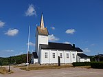
Skjee kirke (12c. church) Stokke Ravei 419 fylkesvei 522 Sandefjord Norway. Cemetery (kirkegård), gate (port) Trees, stone fence Spring Sunny Blue sky Etc 2019 05 16 DSC02063

Skjee Church (Norwegian: Skjee kirke) is a parish church of the Church of Norway in Sandefjord Municipality in Vestfold county, Norway. It is located in the village of Skjee. It is the church for the Skjee parish which is part of the Sandefjord prosti (deanery) in the Diocese of Tunsberg. The white, stone church was built in a long church design around the year 1200 using plans drawn up by an unknown architect. The church seats about 320 people.

Excerpt from the Wikipedia article Skjee Church (License: CC BY-SA 3.0, Authors, Images).

Skjee Church
Stokke Ravei, Sandefjord

Geographical coordinates (GPS) Address External links Nearby Places
placeShow on map

Wikipedia: Skjee ChurchContinue reading on Wikipedia

Geographical coordinates (GPS)

Latitude Longitude
N 59.2364949 ° E 10.28121 °
placeShow on map

Address

Skjee kirke

Stokke Ravei
3160 Sandefjord
Norway
mapOpen on Google Maps

linkWikiData (Q13611311)
linkOpenStreetMap (179594477)

Skjee kirke (12c. church) Stokke Ravei 419 fylkesvei 522 Sandefjord Norway. Cemetery (kirkegård), gate (port) Trees, stone fence Spring Sunny Blue sky Etc 2019 05 16 DSC02063
Share experience

Nearby Places

Sandefjord Airport, Torp

Sandefjord Airport, Torp (Norwegian: Sandefjord lufthavn, Torp; IATA: TRF, ICAO: ENTO) is a minor international airport located 4 nautical miles (7.4 km; 4.6 mi) northeast of Sandefjord and 110 kilometers (68 mi) south of Oslo in Norway. The airport features a 2,989-meter (9,806 ft) runway aligned 18/36. Torp partially serves as a regional airport for Vestfold and in part as a low-cost airport for Eastern Norway and the capital, Oslo. Widerøe have a base at Torp, serving both domestic and shorter International flights. It also sees scheduled flights by Ryanair, Wizzair, Norwegian and KLM Cityhopper. As of 2021, it is the second-largest airport in eastern Norway in terms of flights after Rygge shut down in 2016.The airport was built largely with NATO funding as one of several bases to be used by the United States Air Force in case of war. Construction started in 1953 and the airport was opened on 2 July 1956. By then the military interest in the airport had dwindled. Civilian flights commenced in 1958, and in 1960, a municipal airport company was established to run a civilian sector. Vestfoldfly started operations the following year, and through a series of name changes and acquisitions has become the basis for Widerøe's operations at Torp. International services commenced in 1985 and Mediterranean charter services in 1992. The airport expanded in the 1960s and in 1997 became a Ryanair destination, which marketed it as an airport serving Oslo. The airport markets itself as TORP Sandefjord Airport (Norwegian: TORP Sandefjord lufthavn). The main entry road from European route E18 traverses the birch tree forests of Fokserød Nature Preserve.

Sem, Norway
Sem, Norway

Sem is a village in Tønsberg in Vestfold county, Norway. Sem was a former municipality in Vestfold. The parish of Sæm was established as a municipality January 1, 1838 (see formannskapsdistrikt). According to the 1835 census the municipality had a population of 3,590. On 1 January 1965 the district Stang with 126 inhabitants was incorporated into the former municipality of Borre. On 1 January 1988 the rest was incorporated into the municipality of Tønsberg. Prior to the merger Sem was about three times the size of Tønsberg, which had a population of 21,948. The village of Sem has a population of 1,981, of which 42 people live within the border of the neighboring municipality Stokke. The village is situated five kilometers west of the city of Tønsberg. Originally the municipality and the parish were named after the historic Sem Manor (Sem hovedgård). During the Middle Ages, Sem Manor was a royal and feudal overlord residence at the site where Jarlsberg Manor is located today. King Harald Fairhair chose to install his son Bjorn Farmann as the master of the estate. It was here that Bjorn Farmann was killed by Eric Bloodaxe in 927. In 1673, Peder Schumacher Griffenfeld took over the property which until then had belonged to the King of Denmark. Griffenfeldt named the farm Griffenfeldgård, but three years later it was renamed Jarlsberg Manor (Jarlsberg Hovedgård). In 1682 the buildings on Jarlsberg burned and new buildings of stone were built by the new owner, the Danish-Norwegian Field Marshal Wilhelm Gustav Wedel.