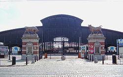
Cureghem
AnderlechtCommons category link is defined as the pagenameNeighbourhoods of BrusselsUse British English from August 2023

Cureghem (French) or Kuregem (Dutch) is a district of Anderlecht, a municipality of Brussels, Belgium. Located in the east of Anderlecht, it is one of this municipality's largest and most populated districts. It developed during the Industrial Revolution along the Brussels–Charleroi Canal and is currently in a fragile social and economic situation due to the decline of its economy and the poor quality of some of its housing.
Excerpt from the Wikipedia article Cureghem (License: CC BY-SA 3.0, Authors, Images).Cureghem
Rue Pasteur - Pasteurstraat,
Geographical coordinates (GPS) Address External links Nearby Places Show on map
Geographical coordinates (GPS)
| Latitude | Longitude |
|---|---|
| N 50.836666666667 ° | E 4.3288888888889 ° |
Address
Rue Pasteur - Pasteurstraat 5
1070
Belgium
Open on Google Maps


