Warnham

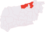
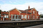
Warnham is a village and civil parish in the Horsham district of West Sussex, England. The village is centred 2 miles (3.2 km) north-northwest of Horsham, 31 miles (50 km) from London, to the west of the A24 road. Other named settlements within the parish include the hamlets of Goosegreen, Kingsfold and Winterfold as well as parts of Strood Green and Rowhook. The area is in the northwest of the Weald, a gently sloped remnant forest in southeast England and largely a plain by erosion. The parish has a land area of 1980 hectares (4892 acres). In the 2001 census 1958 people lived in 784 households, of whom 935 were economically active. At the 2011 Census the population was 2,068. Warnham has a number of shops, including a village store and butcher, two pubs The Sussex Oak and The Greets Inn, a primary school and Warnham railway station lies nearly a mile away from the village, on the Sutton & Mole Valley Lines. The station was built primarily for the brick works, which had some sidings until recently; it offers an hourly service to London Victoria with connections to London Waterloo. The adjacent level crossing is now permanently closed except for pedestrians and cyclists.Gallery
Excerpt from the Wikipedia article Warnham (License: CC BY-SA 3.0, Authors, Images).Warnham
Church Street,
Geographical coordinates (GPS) Address Nearby Places Show on map
Geographical coordinates (GPS)
| Latitude | Longitude |
|---|---|
| N 51.09144 ° | E -0.34659 ° |
Address
Church Street
Church Street
RH12 3QP
England, United Kingdom
Open on Google Maps


