place

Antimonumento +65

2018 establishments in Mexico2018 sculpturesAnti-monuments in MexicoCommons category link is locally definedLabor monuments and memorials
Monuments and memorials in Mexico CityOutdoor sculptures in Mexico CityPaseo de la ReformaSteel sculptures in MexicoUse American English from January 2025
Antimonumento +65 a las víctimas de Pasta de Conchos 03

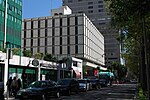
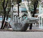
An antimonumento (English: anti-monument) was installed near the Mexican Stock Exchange Building, on Paseo de la Reforma Avenue, in the Cuauhtémoc borough of Mexico City. The work included the installation of the number 65 along with the plus sign to honor the sixty-five miners that died during the 19 February 2006 Pasta de Conchos mine disaster in San Juan de Sabinas Municipality, Coahuila. Only two bodies were recovered as of 2018. Protesters installed the anti-monument during the afternoon of 18 February 2018—the eve of the twelfth anniversary of the disaster—as a plea for justice for the collapse and for justice for the government's inaction. The artwork was never given an official name, and those who installed it referred to it simply as Antimonumento; because of its physical characteristics, it is known as Antimonumento +65, although it is known by other names. The plus symbol in the sculpture is engraved with the names of the victims, coupled with the phrase A una voz, ¡rescate ya! (English: "With one voice, rescue now!"). The plus symbol also carries the meaning of honoring other miners who died under similar circumstances. The following year, the demonstrators placed a metal cage with sixty-three helmets buried in coal mined from a Coahuila mine behind the main sculpture.

Excerpt from the Wikipedia article Antimonumento +65 (License: CC BY-SA 3.0, Authors, Images).

Antimonumento +65
Avenida Paseo de la Reforma, Mexico City

Geographical coordinates (GPS) Address External links Nearby Places
placeShow on map

Wikipedia: Antimonumento +65Continue reading on Wikipedia

Geographical coordinates (GPS)

Latitude Longitude
N 19.428925 ° E -99.164275 °
placeShow on map

Address

Antimonumento 65

Avenida Paseo de la Reforma
06500 Mexico City
Mexico City, Mexico
mapOpen on Google Maps

linkWikiData ()
linkOpenStreetMap (11124264123)

Antimonumento +65 a las víctimas de Pasta de Conchos 03
Share experience

Nearby Places

Zona Rosa, Mexico City

Zona Rosa (English: "Pink Zone") is a neighborhood in Mexico City which is known for its shopping, nightlife, gay community and its recently established Korean community. The neighborhood is officially part of the Colonia Juárez colonia or official neighborhood, located just west of the historic center of Mexico City. The area's history as a community began when it was developed as a residential district for wealthy foreigners and Mexico City residents looking to move from the city center. The development of the area stalled during and after the Mexican Revolution. From the 1950s to 1980s the neighborhood was revitalized by artists, intellectuals and the city's elite who repopulated the area, gave it a bohemian reputation and attracted exclusive restaurants and clubs for visiting politicians and other notables. It was during this time that the area received the name of Zona Rosa, from José Luis Cuevas. The era ended in the 1980s, when many of the upscale businesses moved out and tourism, men's clubs, prostitution and other crime moved in. Although the area declined during the 1980s, it is still a major shopping and entertainment district and has also become a major tourist attraction for the city, one that the city has worked to preserve and rehabilitate since the 2000s, with mixed success. From the 1990s, the area has also become home to Mexico City's gay community, which is prominent around Amberes Street and sponsors an annual pride parade on Paseo de la Reforma.

Colonia Juárez, Mexico City

Colonia Juárez is one of the better-known neighborhoods or colonias in the Cuauhtémoc borough of Mexico City. The neighborhood is shaped like a long triangle with the boundaries: Paseo de la Reforma on the north, Avenida Chapultepec on the south, and Eje 1 Poniente (Avenida Bucareli) on the east. It is located between the historic center of Mexico City and the Chapultepec Park area, just south of the Paseo de la Reforma, which is one of Mexico's main commercial districts and its financial center. Since it was established in the late 19th century and early 20th as a haven for the wealthy leaving the city center, the colonia has been in near constant change. Most of the mansions built in the early part of its history have either been abandoned, converted into businesses or been taken over by squatters. However, it has had a cosmopolitan and intellectual reputation since its founding, which was reinforced with the influx of artists and intellectuals in the 1960s. The area has suffered deterioration since the 1980s, due to the 1985 Mexico City earthquake and other factors, but there have been efforts to restore the area's former prestige, including tourism promotion, historic conservation efforts and the urbanization of areas close to Paseo de la Reforma. The best known area of the colonia is Zona Rosa (Pink Zone) which is a tourist attraction for its artistic and intellectual reputation and is home to Mexico City's gay community. It is also home to "Little Seoul", center of the city's Korean immigrant population.