Hudson Terminal

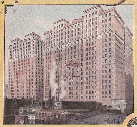
Hudson Terminal was a rapid transit station and office-tower complex in the Radio Row neighborhood of Lower Manhattan in New York City. Opened during 1908 and 1909, it was composed of a terminal station for the Hudson & Manhattan Railroad (H&M), as well as two 22-story office skyscrapers and three basement stories. The complex occupied much of a two-block site bounded by Greenwich, Cortlandt, Church, and Fulton Streets, which later became the World Trade Center site. The railroad terminal contained five tracks and six platforms serving H&M trains to and from New Jersey; these trains traveled via the Downtown Hudson Tubes, under the Hudson River, to the west. The two 22-story office skyscrapers above the terminal, the Fulton Building to the north and the Cortlandt Building to the south, were designed by architect James Hollis Wells of the firm Clinton and Russell in the Romanesque Revival style. The basements contained facilities such as a shopping concourse, an electrical substation, and baggage areas. The complex could accommodate 687,000 people per day, more than Pennsylvania Station in Midtown Manhattan. The buildings opened first, being the world's largest office buildings upon their completion, and the terminal station opened afterward. The H&M was successful until the mid-20th century, when it went bankrupt. The railroad and Hudson Terminal were acquired in 1962 by the Port Authority of New York and New Jersey, which rebranded the railroad as Port Authority Trans-Hudson (PATH). The Port Authority agreed to demolish Hudson Terminal to make way for the World Trade Center, and the railroad station closed in 1971, being replaced by PATH's World Trade Center station. While the buildings were demolished in 1972, the last remnants of the station were removed in the 2000s as part of the development of the new World Trade Center following the September 11 attacks in 2001.
Excerpt from the Wikipedia article Hudson Terminal (License: CC BY-SA 3.0, Authors, Images).Hudson Terminal
Fulton Street, New York Manhattan
Geographical coordinates (GPS) Address Nearby Places Show on map
Geographical coordinates (GPS)
| Latitude | Longitude |
|---|---|
| N 40.711666666667 ° | E -74.011666666667 ° |
Address
World Trade Center Transportation Hub - Oculus
Fulton Street
10048 New York, Manhattan
New York, United States
Open on Google Maps


