place

Victoria Bridge, Worcestershire

1861 establishments in EnglandBridges across the River SevernBridges completed in 1861Cast-iron arch bridges in EnglandGrade II* listed buildings in Worcestershire
Grade II* listed railway bridges and viaductsRailway bridges in WorcestershireUse British English from September 2014
6695 Victoria Bridge Severn Valley Railway

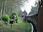
The Victoria Bridge crosses the River Severn between Arley and Bewdley in Worcestershire, England. At the time of its construction, the 200-foot railway bridge was the longest single span cast iron bridge in Britain.The cast-iron arch bridge has four arch ribs each of nine parts bolted together. The arch elements were cast by the Coalbrookdale Company and the bridge was built by Thomas Brassey, Samuel Morton Peto and Edward Betts. Its design is almost identical to the Albert Edward Bridge which spans the Severn at Coalbrookdale in Shropshire, both designed by John Fowler.Opened for traffic on 31 January 1862, the railway line was closed to traffic in 1963. The bridge survived the threat of demolition and was then used by the Severn Valley Railway. In May 1974, heritage passenger services were re-introduced between Alveley Colliery and Bewdley over the Victoria Bridge. It was restored in 2004. The bridge has appeared in several films, including the 1978 film The Thirty-Nine Steps.

Excerpt from the Wikipedia article Victoria Bridge, Worcestershire (License: CC BY-SA 3.0, Authors, Images).

Victoria Bridge, Worcestershire
Arley Lane, Wyre Forest

Geographical coordinates (GPS) Address Nearby Places
placeShow on map

Wikipedia: Victoria Bridge, WorcestershireContinue reading on Wikipedia

Geographical coordinates (GPS)

Latitude Longitude
N 52.410833333333 ° E -2.3444444444444 °
placeShow on map

Address

Arley Lane
DY12 1RY Wyre Forest
England, United Kingdom
mapOpen on Google Maps

6695 Victoria Bridge Severn Valley Railway
Share experience

Nearby Places

Shatterford Hill
Shatterford Hill

Shatterford Hill is an English geographical feature that extends from Bewdley in north Worcestershire to Birdsgreen near Alveley, just over the border in Shropshire. The hill is a long ridge running up the east side of the Severn Valley and peaks at 202 metres near the village of Shatterford on the A442 road between Kidderminster and Bridgnorth. The ridge offers unhindered views across the Severn Valley out west to the Clee Hills, Caer Caradoc, the Long Mynd and on clear days to the hills of Wales. To the east is Kidderminster and the Clent Hills, and the urban West Midlands areas of Dudley beyond. To the north the Wrekin dominates the horizon near Telford, whilst to the south are the Malvern Hills. Although the triangulation pillar that officially marks the summit of the hill is in a field with no public access, next to a small mast, a viewpoint is provided on the Shatterford-Trimpley road with a small layby opposite. Villages along the hill include (south to north), Trimpley, Shatterford and Romsley. The road following the crown of the ridge was probably the Micclan strete (great made-road), mentioned in the Anglo-Saxon bounds of Wolverley. This may have been part of an ancient road from Gloucester and Worcester to Chester. From Shatterford through Romsley and Quatt, thus became part of the Kidderminster to Bridgnorth turnpike, until an easier road (now A442) was built in the 1830s.The ridge comes to a fairly abrupt end to the south, capped by Wassell Wood, where earthworks can still be seen from fortified enclosure of unknown date. The name "Wassell" is derived from the Anglo-Saxon "Weardsetl" meaning a watchplace. This was the westernmost of a chain of such watchplaces, also including Wassell Grove (near Wychbury Hill), Waseley Hills and Wast Hills in Alvechurch.Below Wassell Wood to the east is Habberley Valley, a local nature reserve of lowland heathland, which is a popular picnic site locally.