place

Westgarth railway station

Railway stations in Australia opened in 1888Railway stations in MelbourneRailway stations in the City of DarebinUse Australian English from February 2015
Westgraph Railway Station

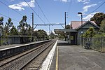
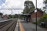
Westgarth railway station is located on the Hurstbridge line in Victoria, Australia. It serves the north-eastern Melbourne suburb of Northcote, and opened on 8 May 1888 as Westgarth Street. It was renamed Northcote South on 1 August 1888, and Westgarth on 10 December 1906.

Excerpt from the Wikipedia article Westgarth railway station (License: CC BY-SA 3.0, Authors, Images).

Westgarth railway station
Evans Crescent, Melbourne Northcote

Geographical coordinates (GPS) Address External links Nearby Places
placeShow on map

Wikipedia: Westgarth railway stationContinue reading on Wikipedia

Geographical coordinates (GPS)

Latitude Longitude
N -37.7807 ° E 144.9993 °
placeShow on map

Address

Westgarth

Evans Crescent
3070 Melbourne, Northcote
Victoria, Australia
mapOpen on Google Maps

linkWikiData (Q7988803)
linkOpenStreetMap (30223632)

Westgraph Railway Station
Share experience

Nearby Places

Bill Lawry Oval

Bill Lawry Oval, formerly known as Northcote Park, is a cricket and Australian rules football stadium located on Westgarth St, Northcote, Victoria. It is most notable as the home ground of the Northcote Cricket Club in the Victorian Premier Cricket, and of the Northcote Football Club in the Victorian Football Association (VFA). Northcote Park was established as a public recreation reserve in the 1860s. However, its location near Merri Creek was relatively distant from the main town, meaning it was neither well patronised nor well maintained during the 19th century, and Croxton Park was the town's favoured venue for sports. After improvements to the ground in the early 1900s, the Northcote Football Club, then playing in the Victorian Junior Football Association, and the Northcote Cricket Club, which was soon a member of the Victorian District Cricket competition both began playing at Northcote Park from 1904. In 1908, the football club (at that stage playing in the Victorian Football Association) returned to Croxton Park from 1909 until 1914; then, returned to Northcote Park in 1915 after the main grandstand was opened. The last of these moves was controversial within the club and resulted in a split of the committee of the Northcote Football Club, after which a splinter group established an entirely new rival club which remained at Croxton Park.The Northcote Football Club remained at the venue from 1915 until it folded at the end of the 1987 season. The Fitzroy Football Club of the Victorian Football League utilised the venue for training (but not for matches) for a few years after being evicted from the Junction Oval at the end of 1984. In 1989, after Fitzroy had departed and Northcote had folded, the Northcote Park Football Club of the Diamond Valley Football League moved to the venue to become its winter football tenant. The Darebin Falcons began using the venue for its VFLW matches from 2018. The Northcote Cricket Club has remained the venue's primary summer cricket tenant to the present day. In 2000, the oval was renamed in honour of Victorian and Australian cricket captain Bill Lawry, who played his district cricket for Northcote.

Clifton Hill, Victoria

Clifton Hill is a suburb of Melbourne, Victoria, Australia, 4 km north-east of the Melbourne central business district. Its local government area is the City of Yarra. At the 2016 Census, Clifton Hill had a population of 6,341. Described in the 1880s as the "Toorak of Collingwood", Clifton Hill fell out of favour, along with much of inner Melbourne, by the mid 20th century. Later becoming a centre of Melbourne's bohemianism, the suburb has undergone rapid gentrification in recent years, with renewed interest in its inner city location and well preserved Victorian and Edwardian housing stock. Clifton Hill now considered one of Melbourne's most liveable suburbs, and is consequently becoming increasingly less affordable, with the median property price increasing from 112% to 160% of the Melbourne metropolitan median in the decade to 1996, and 180% (AUD1.48 million) by 2017.Clifton Hill is located immediately adjacent to Fitzroy North, with which it shares the same postcode. Along with Carlton North and Fitzroy North, Clifton Hill has unusually spacious and picturesque streets, being part of a well preserved government subdivision laid out by Clement Hodgkinson in the 1860s, and most unlike the smaller crowded streets of the majority of inner Melbourne. The border between Clifton Hill and Fitzroy North is Queens Parade and Smith Street while Clifton Hill's border with Collingwood is Alexandra Parade. Merri Creek defines the eastern and northern borders of Clifton Hill with Northcote and Fairfield.