place

Pleasant Street (Yarmouth, Maine)

Streets in Yarmouth, MaineUse American English from February 2022Use mdy dates from February 2022
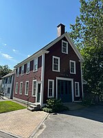
51 Pleasant Street Yarmouth Maine

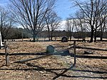
Pleasant Street is a historic street in Yarmouth, Maine, United States. It was formerly part of the Atlantic Highway (or New England Route 1), a precursor to U.S. Route 1. It connects to Lafayette Street, part of today's Maine State Route 88, at Pleasant Street’s southern and northern ends. It has existed since at least 1761, which is when a milestone was placed on the street, on the order of Benjamin Franklin, due to its being on the King's Highway, to denote its distance from Boston, Massachusetts. As part of his duties, Franklin conducted inspections of the roads that were used for delivering mail. One method of charging for mail service was by mileage, so Franklin invented an odometer to measure mileage more accurately. The King's Highway, as a result, morphed into the Post Road. In the mid-19th century, the street became the home of several notable sea captains, due to its proximity to Yarmouth Harbor at the northern end of the street. It is here that the road's elevation drops around 65 feet (from 75 feet (23 m) to 10 feet (3.0 m)) over the course of around 500 feet (150 m). A 2021 Historic Preservation Advisory Ordinance identified ten Local Historic Landmarks, three Historic Districts and three Historic Objects. Many are located in the Gilman Road and Pleasant Street areas, which leads to the possibility of it being a future historic district.

Excerpt from the Wikipedia article Pleasant Street (Yarmouth, Maine) (License: CC BY-SA 3.0, Authors, Images).

Pleasant Street (Yarmouth, Maine)
Pleasant Street,

Geographical coordinates (GPS) Address Nearby Places
placeShow on map

Wikipedia: Pleasant Street (Yarmouth, Maine)Continue reading on Wikipedia

Geographical coordinates (GPS)

Latitude Longitude
N 43.790572 ° E -70.176809 °
placeShow on map

Address

Pleasant Street 180
04096
Maine, United States
mapOpen on Google Maps

51 Pleasant Street Yarmouth Maine
Share experience

Nearby Places

Royal River
Royal River

The Royal River is a small river, 39 miles (63 km) long, in southern Maine. The river originates in Sabbathday Lake in New Gloucester and flows northeasterly into Auburn and then southerly through New Gloucester (via the Royal River Reservoir), Gray and North Yarmouth into Casco Bay at Yarmouth. The river is bridged by Interstate 95 and U.S. Route 202 before leaving New Gloucester, then by the Maine Central Railroad "Back Road" and the Grand Trunk Railway in Auburn, and then again by the Grand Trunk Railway and by State Route 231 when it returns to New Gloucester. The river is bridged twice more by the Maine Central Back Road in Gray. In North Yarmouth, the river is bridged again by State Route 231 and by State Route 9, and in Yarmouth it is crossed by the Maine Central Railroad "Lower Road", again by the Grand Trunk Railway, by U.S. Route 1 and, at its mouth, by State Route 88 (carried by the East Main Street Bridge) and, finally, Interstate 295. The Native Americans called the river Westcustogo River (meaning muddy) or Pumgustuck River (falls at mouth of river).During the 1700s and 1800s, Yarmouth River, as it was then known, was a source of great economic growth for Yarmouth as it provided the power for the many mills. One such mill was erected in 1872 by the Forest Paper Company on the current site of the Royal River Park. The river is mentioned in several of Maine-native Stephen King's novels, including The Body, when the boys cross the Royal River, only to be attacked by leeches, as well as 'Salem's Lot and Rita Hayworth and Shawshank Redemption. The McKin Company Superfund site was within the Royal River watershed.