place

Meetinghouse under the Ledge

1730 establishments in the Thirteen Colonies1836 disestablishments in the United States18th-century churches in the United StatesBuildings and structures demolished in 1836Churches completed in 1729
Churches in Yarmouth, MaineChurches on the National Register of Historic Places in MaineDemolished buildings and structures in MaineDemolished churches in the United StatesFormer churches in Maine

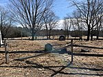
The Meetinghouse under the Ledge, also known as the Old Ledge Meetinghouse, was a church that stood in present-day Yarmouth, Maine, between 1729 (when the town was North Yarmouth, Province of Massachusetts Bay) and 1836 (sixteen years after Maine's admittance to the Union). It was the ninth church founded in Maine.Named for the ledge that rises to the west of its former location, only the church's eastern doorstep remains, beside today's Garrison Lane.

Excerpt from the Wikipedia article Meetinghouse under the Ledge (License: CC BY-SA 3.0, Authors).

Meetinghouse under the Ledge
Gilman Road,

Geographical coordinates (GPS) Address Nearby Places
placeShow on map

Wikipedia: Meetinghouse under the LedgeContinue reading on Wikipedia

Geographical coordinates (GPS)

Latitude Longitude
N 43.7855 ° E -70.1753 °
placeShow on map

Address

Gilman Road 24
04096
Maine, United States
mapOpen on Google Maps

Share experience

Nearby Places

Royal River
Royal River

The Royal River is a small river, 39 miles (63 km) long, in southern Maine. The river originates in Sabbathday Lake in New Gloucester and flows northeasterly into Auburn and then southerly through New Gloucester (via the Royal River Reservoir), Gray and North Yarmouth into Casco Bay at Yarmouth. The river is bridged by Interstate 95 and U.S. Route 202 before leaving New Gloucester, then by the Maine Central Railroad "Back Road" and the Grand Trunk Railway in Auburn, and then again by the Grand Trunk Railway and by State Route 231 when it returns to New Gloucester. The river is bridged twice more by the Maine Central Back Road in Gray. In North Yarmouth, the river is bridged again by State Route 231 and by State Route 9, and in Yarmouth it is crossed by the Maine Central Railroad "Lower Road", again by the Grand Trunk Railway, by U.S. Route 1 and, at its mouth, by State Route 88 (carried by the East Main Street Bridge) and, finally, Interstate 295. The Native Americans called the river Westcustogo River (meaning muddy) or Pumgustuck River (falls at mouth of river).During the 1700s and 1800s, Yarmouth River, as it was then known, was a source of great economic growth for Yarmouth as it provided the power for the many mills. One such mill was erected in 1872 by the Forest Paper Company on the current site of the Royal River Park. The river is mentioned in several of Maine-native Stephen King's novels, including The Body, when the boys cross the Royal River, only to be attacked by leeches, as well as 'Salem's Lot and Rita Hayworth and Shawshank Redemption. The McKin Company Superfund site was within the Royal River watershed.