place

Ledge Cemetery

1770 establishments in the Thirteen ColoniesCemeteries established in the 1770sCemeteries in Yarmouth, Maine
Ledge Cemetery 2
Ledge Cemetery 2

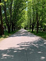
Ledge Cemetery, also known as the Cemetery under the Ledge, is a historic cemetery in Yarmouth, Maine, United States. Dating to 1770, it stands on Gilman Road, around 450 feet (140 m) southwest of the older and smaller Pioneer Cemetery. Some headstones bear dates earlier than 1770, for many burials — such as that of Revd. Nicholas Loring — were removed from the older cemeteryThe original First Parish Congregational Church, known as the Old Ledge Meetinghouse, stood near the site between 1730 and 1818. Its first pastor was Reverend Ammi Ruhamah Cutter. Tristram Gilman, for whom Gilman Road is named, was the fourth pastor. He served in the role for forty years, and was buried in the Ledge Cemetery upon his death in 1809, aged 73. His wife, Elizabeth Sayer, is buried beside him.Several sea captains are also interred here, including those from the Drinkwater family. Captain Theophilus Drinkwater, son of Allen and Hannah Drinkwater, gave his name to nearby Drinkwater Point Road.Of a settlement that originally contained a school, a tavern and a cemetery, only the cemetery and the ledge doorstep of the church remain.

Excerpt from the Wikipedia article Ledge Cemetery (License: CC BY-SA 3.0, Authors, Images).

Ledge Cemetery
Gilman Road,

Geographical coordinates (GPS) Address Nearby Places
placeShow on map

Wikipedia: Ledge CemeteryContinue reading on Wikipedia

Geographical coordinates (GPS)

Latitude Longitude
N 43.7847 ° E -70.1757 °
placeShow on map

Address

Gilman Road 23
04096
Maine, United States
mapOpen on Google Maps

Ledge Cemetery 2
Ledge Cemetery 2
Share experience

Nearby Places

Royal River
Royal River

The Royal River is a small river, 39 miles (63 km) long, in southern Maine. The river originates in Sabbathday Lake in New Gloucester and flows northeasterly into Auburn and then southerly through New Gloucester (via the Royal River Reservoir), Gray and North Yarmouth into Casco Bay at Yarmouth. The river is bridged by Interstate 95 and U.S. Route 202 before leaving New Gloucester, then by the Maine Central Railroad "Back Road" and the Grand Trunk Railway in Auburn, and then again by the Grand Trunk Railway and by State Route 231 when it returns to New Gloucester. The river is bridged twice more by the Maine Central Back Road in Gray. In North Yarmouth, the river is bridged again by State Route 231 and by State Route 9, and in Yarmouth it is crossed by the Maine Central Railroad "Lower Road", again by the Grand Trunk Railway, by U.S. Route 1 and, at its mouth, by State Route 88 (carried by the East Main Street Bridge) and, finally, Interstate 295. The Native Americans called the river Westcustogo River (meaning muddy) or Pumgustuck River (falls at mouth of river).During the 1700s and 1800s, Yarmouth River, as it was then known, was a source of great economic growth for Yarmouth as it provided the power for the many mills. One such mill was erected in 1872 by the Forest Paper Company on the current site of the Royal River Park. The river is mentioned in several of Maine-native Stephen King's novels, including The Body, when the boys cross the Royal River, only to be attacked by leeches, as well as 'Salem's Lot and Rita Hayworth and Shawshank Redemption. The McKin Company Superfund site was within the Royal River watershed.