place

River Keer

Cumbria geography stubsEngland river stubsLancashire geography stubsRivers of CumbriaRivers of Lancashire
Rivers of LancasterWestmorland
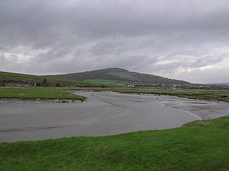
Bend in Keer
Bend in Keer

The River Keer is a river in England. It flows through the English counties of Lancashire and Cumbria. For parts of its course, the Keer marks the boundary between Lancashire and Cumbria, as well as the ancient counties of Lancashire and Westmorland. The river rises on Docker Moor near the village of Whittington and follows a westerly course, passing the villages of Capernwray, Borwick and Warton, as well as Pine Lake, before reaching Carnforth, after which the river runs through salt marshes before pouring into the Kent estuary and Morecambe Bay.

Excerpt from the Wikipedia article River Keer (License: CC BY-SA 3.0, Authors, Images).

River Keer
Crag Bank Road, Lancaster

Geographical coordinates (GPS) Address Nearby Places
placeShow on map

Wikipedia: River KeerContinue reading on Wikipedia

Geographical coordinates (GPS)

Latitude Longitude
N 54.128888888889 ° E -2.7925 °
placeShow on map

Address

Crag Bank Road
LA5 9JA Lancaster
England, United Kingdom
mapOpen on Google Maps

Bend in Keer
Bend in Keer
Share experience

Nearby Places

Warton Crag
Warton Crag

Warton Crag is a limestone hill in north west Lancashire, England. It lies to the north west of Warton village, in City of Lancaster district. At 163 metres (535 ft) it is the highest point in the Arnside and Silverdale Area of Outstanding Natural Beauty, and is listed as a "HuMP" or "Hundred Metre Prominence", having a "drop" or "prominence" of 126 metres (413 ft) with its parent being Hutton Roof Crags. Two areas are Local Nature Reserves, called Warton Crag and Warton Crag Quarry. Different sections are owned by Lancashire County Council, the Wildlife Trust for Lancashire, Manchester and North Merseyside, Lancaster City Council and the Royal Society for the Protection of Birds.Two caves on the west side of the hill called Dog Holes and Badger Hole show signs of early human occupation, with excavations finding a range of artefacts.The summit of the hill is the site of a small multivallate hillfort, which has long been assumed to date to the Iron Age period. The approximately 3.2-hectare (7.9-acre) enclosure was defended by rock scarps and steep slopes to the south and west with triple stone ramparts forming an arc on the other sides. However research by Historic England in 2016 using lidar proposed that the structure was instead "some form of non-defensive hilltop enclosure, possibly dating to the Late Bronze Age." A beacon was erected on the crag in 1988 as part of a re-enactment of the beacon chain alerting the country to the Spanish Armada, on its 400th anniversary. It was lit again in 2012 for the Diamond Jubilee of Elizabeth II, in 2016 for her 90th birthday, and in 2022 for her Platinum Jubilee.Many plants are found on the crag, including horseshoe vetch near its northern limit, spindle tree and many ferns. The site is rich in butterflies, including the rare pearl bordered fritillary and high brown fritillary. Much of the hill is listed as a Site of Special Scientific Interest, being considered the best example of limestone grassland in Lancashire, with areas of Limestone pavement.The former quarry on the west of the crag is a regular breeding site for peregrine falcons and is protected by a Falcon Watch team of volunteers.The crag is used by rock-climbers, and a fell race on the crag takes place annually as part of Warton Children's Sports Day.

Bolton-le-Sands
Bolton-le-Sands

Bolton-le-Sands is a large village and civil parish of the City of Lancaster in Lancashire, England. The parish had a population of 4,098 recorded in the 2001 census, increasing to 4,127 at the 2011 Census.Referred to as Bodeltone in the Domesday book, the village was known as Bolton until the arrival of the railways, when the name was changed to Bolton-le-Sands to differentiate from similarly named towns on the same line, such as Bolton which was then a part of Lancashire and called Bolton-le-Moors. The oldest church in the village, founded prior to 1094, is the Church of England Holy Trinity church, originally dedicated to St Michael. The oldest part of the current building is the tower, supposed to have been built around 1500. The nave and chancel date from the 19th century. The other churches are the Roman Catholic St Mary of the Angels and the Christ Church United Reformed Church. The Lancaster Canal, built in the 1790s, is a major feature of the village. Also passing through the village is the A6 and the West Coast Main Line, although its railway station closed in 1969. The village includes three pubs: The Royal Hotel, situated on the A6, The Packet Boat (closed in 2015), and the Blue Anchor are both within the centre of the village, along the main street. The village has one school, Bolton-le-Sands Church of England Primary School, with 320 pupils from the ages of 4 to 11 in a modern school building. It has received a 2022 Ofsted report with GOOD in all areas. The school is a successor to the old Boys' Free Grammar School, which dates from 1657, with the 19th century school building still used for community education. The school building was also home to the Bolton-le-Sands library until 1973, when the library was moved into a newly built site in the village centre. The library was controversially closed in Autumn 2016 following a renovation in 2015 costing a reported £283,000.The village has a very active scout group that meets in the scout hut on the village playing fields. It has three sections; Beavers, Cubs and Scouts.

Old Rectory, Warton
Old Rectory, Warton

The Old Rectory (also known as Parsonage Court) is a ruin of a former rectory in the village of Warton, near Lancaster, Lancashire, England. Owned by English Heritage, it has been designated a Scheduled Ancient Monument and Grade I listed building.The rectory is believed to have been built in the early 14th century as the residence of the rector of the parish of St Oswald's, Warton, probably by two younger sons of Marmaduke, Lord Thweng. Manorial courts were also held here. The walls are of limestone rubble with sandstone dressings, and a cross passage originally separated the full-height great hall on the southern side from service rooms and a first floor chamber at the other end of the house. The doorway at the eastern end of the cross passage is interpreted as the main entrance, while the western one led into a garden, and both originally had a porch. A doorway in the northern gable wall led into a courtyard with an external kitchen and a well. In the south-west corner of the great hall is a doorway that led to another building which survives as part of the modern vicarage. The southern gable had an ogee quatrefoiled window under the apex to provide light.It is not known exactly when the rectory was abandoned, after being replaced by a new rectory, but it was a ruin by 1721. Some time later, a cottage was constructed in the north end of the ruin, which was occupied well into the 20th century, however these additions have since been removed. The ruin is considered to be well preserved, with the gables surviving to almost their full height. It is open to visitors, free of charge.