Heathylee
Civil parishes in StaffordshireStaffordshire Moorlands

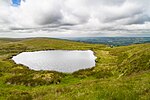
Heathylee is a civil parish in the district of Staffordshire Moorlands in north-east Staffordshire, England. There is no village centre. The parish has a boundary with Leekfrith in the west and with Hollinsclough in the north; there is a short eastern boundary, at the River Manifold, with Sheen, and to the south are the parishes of Bradnop, Onecote and Longnor. Morridge separates the area into a western part, drained by the River Churnet, and a larger eastern part drained by the Manifold and its tributary Oakenclough Brook. The hamlet of Upper Hulme is in the south-west.
Excerpt from the Wikipedia article Heathylee (License: CC BY-SA 3.0, Authors, Images).Heathylee
Leek Road, Staffordshire Moorlands Heathylee
Geographical coordinates (GPS) Address Nearby Places Show on map
Geographical coordinates (GPS)
| Latitude | Longitude |
|---|---|
| N 53.173055555556 ° | E -1.9563888888889 ° |
Address
Leek Road
Leek Road
SK17 0QW Staffordshire Moorlands, Heathylee
England, United Kingdom
Open on Google Maps


