Three Shire Heads
Geography of CheshireGeography of DerbyshireGeography of Staffordshire

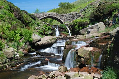
Three Shire Heads (also known as Three Shires Head) is the point on Axe Edge Moor where Cheshire, Derbyshire and Staffordshire meet, at UK grid reference SK009685, or 53.213°N 1.987°W / 53.213; -1.987. It is on the River Dane, which marks the Cheshire border in this area. On the east of the river, the border between Staffordshire and Derbyshire runs north-east for about a mile to Cheeks Hill, on the higher regions of Axe Edge Moor. From Cheeks Hill the border runs south then east to the head of the River Dove.The main landmark is a packhorse bridge. The bridge is Grade II-listed, and was probably constructed in the late 18th century.
Excerpt from the Wikipedia article Three Shire Heads (License: CC BY-SA 3.0, Authors, Images).Three Shire Heads
Pannierspool Bridge, High Peak Hartington Upper Quarter
Geographical coordinates (GPS) Address Nearby Places Show on map
Geographical coordinates (GPS)
| Latitude | Longitude |
|---|---|
| N 53.213 ° | E -1.987 ° |
Address
Pannierspool Bridge
Pannierspool Bridge
SK11 0BQ High Peak, Hartington Upper Quarter
England, United Kingdom
Open on Google Maps


