place

Rautaharkko

Districts of TampereWestern Finland Province geography stubs
Cross panoramio (7)
Cross panoramio (7)

Rautaharkko is a district of Tampere, Finland, located about three kilometers from the city center. Rautaharkko is bordered on the west by Rantaperkiö, on the east by Taatala and Nirva, on the south by Lakalaiva and on the north by Vihioja and Hatanpää. As of 31 December 2014, Rautaharkko had 533 inhabitants.

Excerpt from the Wikipedia article Rautaharkko (License: CC BY-SA 3.0, Authors, Images).

Rautaharkko
Rautaharkonkatu, Tampere Rautaharkko (Eteläinen suuralue)

Geographical coordinates (GPS) Address Nearby Places
placeShow on map

Wikipedia: RautaharkkoContinue reading on Wikipedia

Geographical coordinates (GPS)

Latitude Longitude
N 61.472100126359 ° E 23.771280443266 °
placeShow on map

Address

Rautaharkonkatu

Rautaharkonkatu
33840 Tampere, Rautaharkko (Eteläinen suuralue)
Finland
mapOpen on Google Maps

Cross panoramio (7)
Cross panoramio (7)
Share experience

Nearby Places

Viinikka
Viinikka

Viinikka is a district of Tampere, Finland, located 1,5 kilometers southeast of its city center on the west side of Lake Iides. Its neighboring district is Nekala. Its construction began in 1914 on the former lands of Hatanpää Manor. The stone church, opened in 1932, is located in Viinikka.Viinikka's main streets are Viinikankatu in a north–south direction and Kuokkamaantie in a west–east direction from Lempääläntie to Nekala. The original name of Viinikankatu in 1939–1956 was Hervannantie, but the name was considered misleading because Hervanta is located quite far from the Viinikka district. Before the major street name reform carried out in Tampere in 1936, the current Tuomiokirkonkatu in the center of Tampere was known as Viinikankatu. Ahlmanintie, on the east side of Viinikankatu, is named after Gabriel Ahlman (1737–1799), an assessor who owned the Hatanpää Manor in the late 18th century. The land register of 1540 mentioned the village of Otavala, which belonged to Messukylä, where the houses of Otavala and Viinikka were located. The name Viinikka is thought to be of German origin. In 1757, Otavala passed to Hans Henrik Boije (1716–1781), the owner of the Hatanpää Manor and member of Parliament, who established a spinning school and a flax weaving mill on the farm. The school, called the “Otavalan spinni”, was designed to teach the handling of flax from sowing the seed to weaving the fabric. The spinning school, which had become a pawn of party politics at the time, was closed down after only a few years of operation, but it had time to pave the way for the flax mills established in Tampere in the 19th century. The Viinikka area was annexed to the city of Tampere after the Hatanpää Manor became the property of the city in 1913 and was reserved for a detached house. Viinikka's first town plan was approved in 1914, when the area was bounded on the north by Viinikanoja, on the east by Lake Iides and the Pahaoja pond, on the south by Pahalampi and on the west by the Riihimäki–Tampere railway. The town plans of the area were not finally approved until 1936–1954.

Hatanpää
Hatanpää

Hatanpää (Finnish pronunciation: [ˈhɑtɑŋˌpæː]) is a district in Tampere, Finland, located in the southern part of the city center on the shores of Lake Pyhäjärvi. Hatanpää is actually a peninsula that protrudes towards the lake, leaving the waters of Viinikanlahti Bay to the north and Vihilahti Bay to the south. The area is named after Hatanpää Manor, whose land from Härmälä to Sääksjärvi and Nekala was bought for the city in 1913. Administratively, the area has belonged to the city since 1920. In 2014, the population of the area was measured as 2,686 inhabitants.Hatanpää is a well-known district because of its many significant sites, including Hatanpää Manor, Hatanpää Park and Hatanpää Arboretum, primary school and high school, and TAYS' second large hospital area, Hatanpää Hospital, as well as a large number of car dealerships and industry. The busy Hatanpää Highway (Hatanpään valtatie), which branches off from Hämeenkatu, leads directly to the area, sideways to the bus station and Viinikanlahti, and strongly divides it in two. On the east side of the road there are industry and car shops, on the west side and closer to the center there are large office buildings and further south the residential area bordering Hatanpää Park. Several IT companies are located in former houses of Nokia in Hatanpää and in former Sarvis properties. In the vicinity of the office buildings is the Viinikka's wastewater treatment plant, which causes local odor nuisances. However, odor nuisances do not affect residential and park areas. A lot of new things are being built in Hatanpää and this is how the district grows and develops. The water treatment plant will be transferred to a new central treatment plant planned to be started in 2024, which will be excavated in Sulkavuori. A new residential area in Viinikanlahti has been planned for the area of the mobile treatment plant, where an idea competition was held in 2019 and the results were published in 2020. In addition, a new residential area is planned on the old plot of the city's garden unit right next to Hatanpää Park.

Tampere Bus Station
Tampere Bus Station

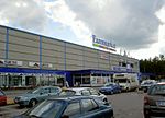
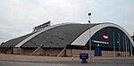
The Tampere Bus Station (Finnish: Tampereen linja-autoasema) is a bus station in the city center of Tampere, Finland, located in the Ratina district along the Hatanpää Highway. It takes about 20 minutes by bus to Tampere Airport from the bus station. The bus station, designed by Jaakko Laaksovirta and Bertel Strömmer, representing functionalist architecture, was completed in 1938, and is now a protected cultural site as well as an architectural attraction. When completed, it was also the largest bus station in the Nordic countries.The bus station was at its busiest in the late 1960s, with around 470 departures on normal weekdays. By the end of the 1980s, the number had shrunk to less than 400, mainly due to an increase in the car traffic, but also partly due to the relocation of some local routes to the Pyynikintori square. When the cargo handling facilities at the bus station had become cramped, a new freight station was built between the bus station and the Tampere Highway, which was opened in early 1985. The bus station also had the office of Länsilinjat Oy until 1984, when all the company's operations moved to new premises in the Sarankulma's industrial area. Between 1995 and 2004, the relocation of the bus station to the Central Station was examined in several stages in connection with the national transport hub project. The work also examined the model of a decentralized transport hub, where the bus station would remain in the Ratina district. On 31 May 2004, the City Council's planning department decided that the bus station would remain in its original location. A major renovation of the Tampere bus station began in December 2007, which lasted about a year, where the departure platforms were moved to the east of the station, and the parking spaces for buses were removed. The renovation was completed in late 2008, when the retail premises at the north end of the building were completed. The construction of the future Ratina shopping center was taken into account in the renovation and renovation work. The shopping center was built in 2015–2018 between Ratina Stadium and the bus station, and at the same time the Vuolteenkatu street, which passed through the shopping center site, was moved just behind the bus station. The bus station also provides direct access to the shopping center via escalators.

Ratina (district)
Ratina (district)

Ratina is a district in the center of Tampere, Finland, on the east side of Tammerkoski. The Ratina Stadium, Tampere Bus Station and Tampere's largest shopping mall, the Ratina shopping centre, are located in the district, among others. To the north of Ratina is also the Koskikeskus shopping centre. The district consists of a peninsula called Ratinanniemi, which is surrounded on three sides by Ratinansuvanto and Viinikanlahti. Between Ratinanniemi and the Laukontori square is a pedestrian bridge called Laukonsilta, which significantly shortens travel time to the city center. The Tampere highway has good connections to the Helsinki-Tampere motorway and along it to the Tampere Ring Road, and via the Ratinansilta bridge and the Hämeenpuisto park to Highway 12. Ratinanranta is the southern part of the Tampere highway from Ratina, which used to be a recreation ground and factory area. Its new construction into a dense apartment building area of 1,000 inhabitants began in 2008, and the latest residential buildings east of the Voimakatu street are expected to be completed in 2013. The name ratina probably dates back to the road meaning rata. Ratinanniemi, which lies between the Ratina Reservoir and Lake Pyhäjärvi's Viinikanlahti, remained uninhabited for a long time, until a few residential buildings began to rise there in the late 19th century. In 1874 a glass factory was built on the peninsula and a dozen years later two machine shops, but all these companies remained short-lived. Later, a brick factory and the city's electric power station operated in the area. The first town plan for the Ratinanniemi district was completed in 1886, according to which a total of 57 residential estates were reserved in the area, the smallest of which were for villa buildings. The plan for the eastern part of the Ratina district, with an area reserved for a new bus station, was confirmed in 1935.