place

Sori Square

KyttäläSquares in TampereWestern Finland Province geography stubs
Sori square1
Sori square1

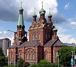
The Sori Square (Finnish: Sorin aukio) is a square located in the center of Tampere, Finland, in the southern part of the Kyttälä district. It is located in the area bounded by the Hatanpää Highway, Suvantokatu, Tuomiokirkonkatu and Vuolteenkatu. At the eastern end of the square is the Tampere Orthodox Church from 1898. There is a terminus at Tampere Tram Line 1 on the west side.The square was built in the 1980s, and its artistic composition was by sculptor Harry Kivijärvi. In the square is his 10-meter sculpture called Pirkka. Kivijärvi has also designed the area's lamps, benches and trash bins, as well as a mosaic-decorated water basin in the northern corner of the square. The work was completed in the autumn of 1987.The name of Sori Square was marked in the town plan in 1985. It is based on the old place name Sorinahde; the hill that rises from Ratina towards Kalevankangas has been called Sorinahde, and the square is located in the middle of the hill.

Excerpt from the Wikipedia article Sori Square (License: CC BY-SA 3.0, Authors, Images).

Sori Square
Sorin aukio, Tampere Kyttälä B (Keskustan suuralue)

Geographical coordinates (GPS) Address Nearby Places
placeShow on map

Wikipedia: Sori SquareContinue reading on Wikipedia

Geographical coordinates (GPS)

Latitude Longitude
N 61.495 ° E 23.770277777778 °
placeShow on map

Address

Sorin aukio

Sorin aukio
33100 Tampere, Kyttälä B (Keskustan suuralue)
Finland
mapOpen on Google Maps

Sori square1
Sori square1
Share experience

Nearby Places

Tampere Bus Station
Tampere Bus Station

The Tampere Bus Station (Finnish: Tampereen linja-autoasema) is a bus station in the city center of Tampere, Finland, located in the Ratina district along the Hatanpää Highway. It takes about 20 minutes by bus to Tampere Airport from the bus station. The bus station, designed by Jaakko Laaksovirta and Bertel Strömmer, representing functionalist architecture, was completed in 1938, and is now a protected cultural site as well as an architectural attraction. When completed, it was also the largest bus station in the Nordic countries.The bus station was at its busiest in the late 1960s, with around 470 departures on normal weekdays. By the end of the 1980s, the number had shrunk to less than 400, mainly due to an increase in the car traffic, but also partly due to the relocation of some local routes to the Pyynikintori square. When the cargo handling facilities at the bus station had become cramped, a new freight station was built between the bus station and the Tampere Highway, which was opened in early 1985. The bus station also had the office of Länsilinjat Oy until 1984, when all the company's operations moved to new premises in the Sarankulma's industrial area. Between 1995 and 2004, the relocation of the bus station to the Central Station was examined in several stages in connection with the national transport hub project. The work also examined the model of a decentralized transport hub, where the bus station would remain in the Ratina district. On 31 May 2004, the City Council's planning department decided that the bus station would remain in its original location. A major renovation of the Tampere bus station began in December 2007, which lasted about a year, where the departure platforms were moved to the east of the station, and the parking spaces for buses were removed. The renovation was completed in late 2008, when the retail premises at the north end of the building were completed. The construction of the future Ratina shopping center was taken into account in the renovation and renovation work. The shopping center was built in 2015–2018 between Ratina Stadium and the bus station, and at the same time the Vuolteenkatu street, which passed through the shopping center site, was moved just behind the bus station. The bus station also provides direct access to the shopping center via escalators.

Ratina (district)
Ratina (district)

Ratina is a district in the center of Tampere, Finland, on the east side of Tammerkoski. The Ratina Stadium, Tampere Bus Station and Tampere's largest shopping mall, the Ratina shopping centre, are located in the district, among others. To the north of Ratina is also the Koskikeskus shopping centre. The district consists of a peninsula called Ratinanniemi, which is surrounded on three sides by Ratinansuvanto and Viinikanlahti. Between Ratinanniemi and the Laukontori square is a pedestrian bridge called Laukonsilta, which significantly shortens travel time to the city center. The Tampere highway has good connections to the Helsinki-Tampere motorway and along it to the Tampere Ring Road, and via the Ratinansilta bridge and the Hämeenpuisto park to Highway 12. Ratinanranta is the southern part of the Tampere highway from Ratina, which used to be a recreation ground and factory area. Its new construction into a dense apartment building area of 1,000 inhabitants began in 2008, and the latest residential buildings east of the Voimakatu street are expected to be completed in 2013. The name ratina probably dates back to the road meaning rata. Ratinanniemi, which lies between the Ratina Reservoir and Lake Pyhäjärvi's Viinikanlahti, remained uninhabited for a long time, until a few residential buildings began to rise there in the late 19th century. In 1874 a glass factory was built on the peninsula and a dozen years later two machine shops, but all these companies remained short-lived. Later, a brick factory and the city's electric power station operated in the area. The first town plan for the Ratinanniemi district was completed in 1886, according to which a total of 57 residential estates were reserved in the area, the smallest of which were for villa buildings. The plan for the eastern part of the Ratina district, with an area reserved for a new bus station, was confirmed in 1935.

Tampere Central Station

Tampere Central Station is a functionalist building in Tampere, Finland, designed by Eero Seppälä and Otto Flodin, completed in 1936. The station is one of the most important railway stations in Finland. In 2015, the Tampere Central Station was the second busiest railway station in Finland in terms of numbers of passengers, after the Helsinki Central Station.The 36-metre clock tower was later added because the Finnish railway bureau required it (its total height from ground level is about 50 metres). The city's main street Hämeenkatu begins at the railway station, continuing over the Hämeensilta bridge to its western end at the Aleksanteri Church. The Itsenäisyydenkatu (originally called Puolimatkankatu) street begins at the Tammela side of the station, continuing to the Kaleva Church. Situated in a central location, the station and its railway yard have served as divisors of the city's districts almost in the same way as Tammerkoski: Tamperean places are often located by saying which side of the station they are on. For decades, there has been discussion of a unified travel centre in Tampere: currently, the long-distance bus terminal, the Tampere Bus Station, is quite far away from the railway station. There are currently three platforms in the Tampere railway station, two of which have a roof. There are five tracks in total, but there are plans to add a fourth platform, making seven tracks in total. The Tampere cargo station is located south from the passenger station. It includes one of the busiest railway organisation yards in Finland. The green building on the east side of the tracks, opposite the old passenger station is the old cargo station. A track leads from the cargo station, over the highway to Helsinki, to the Nekala district, which previously contained many private tracks servicing stock companies. Nowadays, some of the tracks have been disassembled and some are disused. The starting point of the track is used to store train carriages.