Bödeli

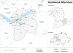
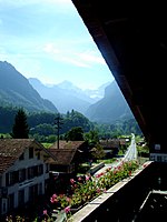
Bödeli (lit.: the Swiss German diminutive term for ground) is the tongue of land between Lake Thun and Lake Brienz in the Bernese Oberland of Switzerland. Lake Thun and Lake Brienz were not yet separate after the last ice age. The rivers Lütschine from the south and the Lombach from the north brought enough debris to cause a partitioning over the millennia. Now Lake Brienz has a water level about 2 metres (6.6 ft) higher than Lake Thun and the river Aare flows from one lake to the other through the Bödeli. On the Bödeli are situated the villages and towns of Unterseen, Interlaken and Matten, which form a closed settlement area, and at the southern border are the villages of Wilderswil and Bönigen. From the south a hill range, the Ruuge, rises up.
Excerpt from the Wikipedia article Bödeli (License: CC BY-SA 3.0, Authors, Images).Bödeli
Aarmühlestrasse,
Geographical coordinates (GPS) Address Nearby Places Show on map
Geographical coordinates (GPS)
| Latitude | Longitude |
|---|---|
| N 46.684 ° | E 7.854 ° |
Address
Aarmühlestrasse 6
3800
Bern, Switzerland
Open on Google Maps


